You are here: Home > Network List > AU - Australian Seismological Centre Stations List
> Station WB2 Warramunga Array, NT > Earthquake Result Viewer
WB2 Warramunga Array, NT - Earthquake Result Viewer
| Earthquake location: |
Samoa Islands Region |
| Earthquake latitude/longitude: |
-15.5/-172.1 |
| Earthquake time(UTC): |
2009/09/29 (272) 17:48:10 GMT |
| Earthquake Depth: |
18 km |
| Earthquake Magnitude: |
7.1 MB, 8.1 MS, 8.1 MW, 8.0 MW |
| Earthquake Catalog/Contributor: |
WHDF/NEIC |
|
| Network: |
AU Australian Seismological Centre |
| Station: |
WB2 Warramunga Array, NT |
| Lat/Lon: |
19.94 S/134.35 E |
| Elevation: |
425 m |
|
| Distance: |
51.0 deg |
| Az: |
256.722 deg |
| Baz: |
94.091 deg |
| Ray Param: |
0.06764546 |
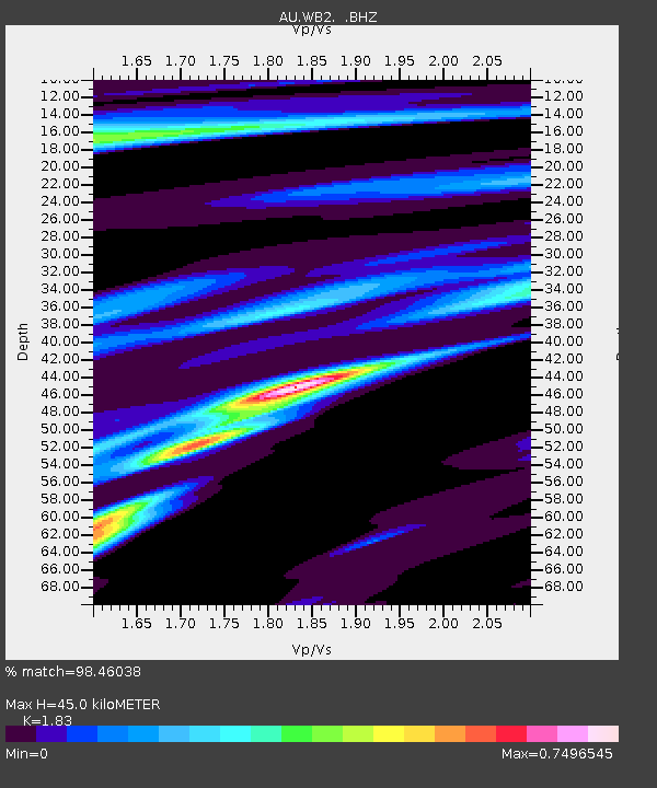
| Estimated Moho Depth: |
45.0 km |
| Estimated Crust Vp/Vs: |
1.83 |
| Assumed Crust Vp: |
6.642 km/s |
| Estimated Crust Vs: |
3.63 km/s |
| Estimated Crust Poisson's Ratio: |
0.29 |
|
| Radial Match: |
98.46038 % |
| Radial Bump: |
303 |
| Transverse Match: |
98.415665 % |
| Transverse Bump: |
286 |
| SOD ConfigId: |
2622 |
| Insert Time: |
2010-03-09 00:30:51.433 +0000 |
| GWidth: |
2.5 |
| Max Bumps: |
400 |
| Tol: |
0.001 |
|

Signal To Noise
| Channel | StoN | STA | LTA |
| AU:WB2: :BHZ:20090929T17:56:41.025004Z | 4.085769 | 1.8006562E-6 | 4.4071413E-7 |
| AU:WB2: :BHN:20090929T17:56:41.025004Z | 2.6896198 | 7.2640887E-7 | 2.7007866E-7 |
| AU:WB2: :BHE:20090929T17:56:41.025004Z | 4.5997715 | 9.004495E-7 | 1.9575963E-7 |
| Arrivals |
| Ps | 6.0 SECOND |
| PpPs | 18 SECOND |
| PsPs/PpSs | 24 SECOND |


