You are here: Home > Network List > AU - Australian Seismological Centre Stations List
> Station WB2 Warramunga Array, NT > Earthquake Result Viewer
WB2 Warramunga Array, NT - Earthquake Result Viewer
| Earthquake location: |
Southern Sumatra, Indonesia |
| Earthquake latitude/longitude: |
-0.7/99.9 |
| Earthquake time(UTC): |
2009/09/30 (273) 10:16:09 GMT |
| Earthquake Depth: |
81 km |
| Earthquake Magnitude: |
7.1 MB, 7.5 MW, 7.5 MW |
| Earthquake Catalog/Contributor: |
WHDF/NEIC |
|
| Network: |
AU Australian Seismological Centre |
| Station: |
WB2 Warramunga Array, NT |
| Lat/Lon: |
19.94 S/134.35 E |
| Elevation: |
425 m |
|
| Distance: |
38.8 deg |
| Az: |
121.731 deg |
| Baz: |
295.309 deg |
| Ray Param: |
0.07511335 |
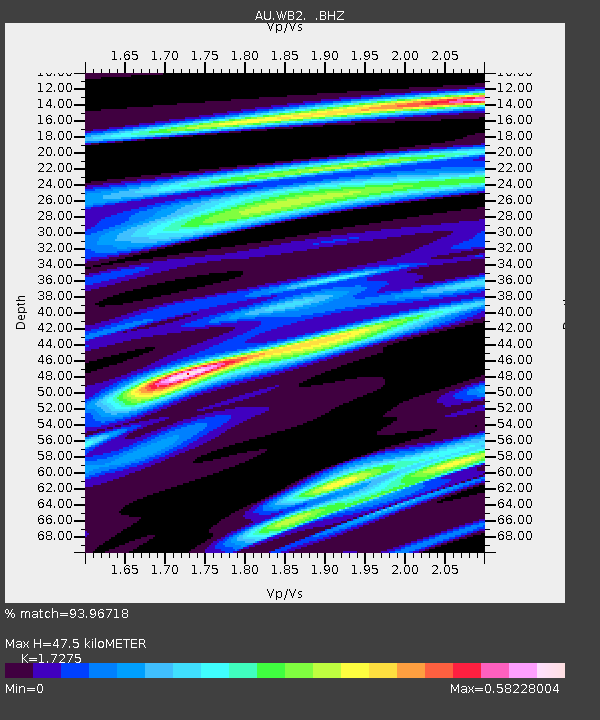
| Estimated Moho Depth: |
47.5 km |
| Estimated Crust Vp/Vs: |
1.73 |
| Assumed Crust Vp: |
6.642 km/s |
| Estimated Crust Vs: |
3.845 km/s |
| Estimated Crust Poisson's Ratio: |
0.25 |
|
| Radial Match: |
93.96718 % |
| Radial Bump: |
220 |
| Transverse Match: |
94.95135 % |
| Transverse Bump: |
318 |
| SOD ConfigId: |
2622 |
| Insert Time: |
2010-03-09 00:30:52.788 +0000 |
| GWidth: |
2.5 |
| Max Bumps: |
400 |
| Tol: |
0.001 |
|

Signal To Noise
| Channel | StoN | STA | LTA |
| AU:WB2: :BHZ:20090930T10:22:55.500Z | 47.963585 | 8.009993E-6 | 1.6700153E-7 |
| AU:WB2: :BHN:20090930T10:22:55.500Z | 11.487577 | 1.8096631E-6 | 1.5753217E-7 |
| AU:WB2: :BHE:20090930T10:22:55.500Z | 47.458992 | 6.1137202E-6 | 1.2882111E-7 |
| Arrivals |
| Ps | 5.6 SECOND |
| PpPs | 18 SECOND |
| PsPs/PpSs | 24 SECOND |


