You are here: Home > Network List > CI - Caltech Regional Seismic Network Stations List
> Station MPM Manuel Prospect Mine, California, USA > Earthquake Result Viewer
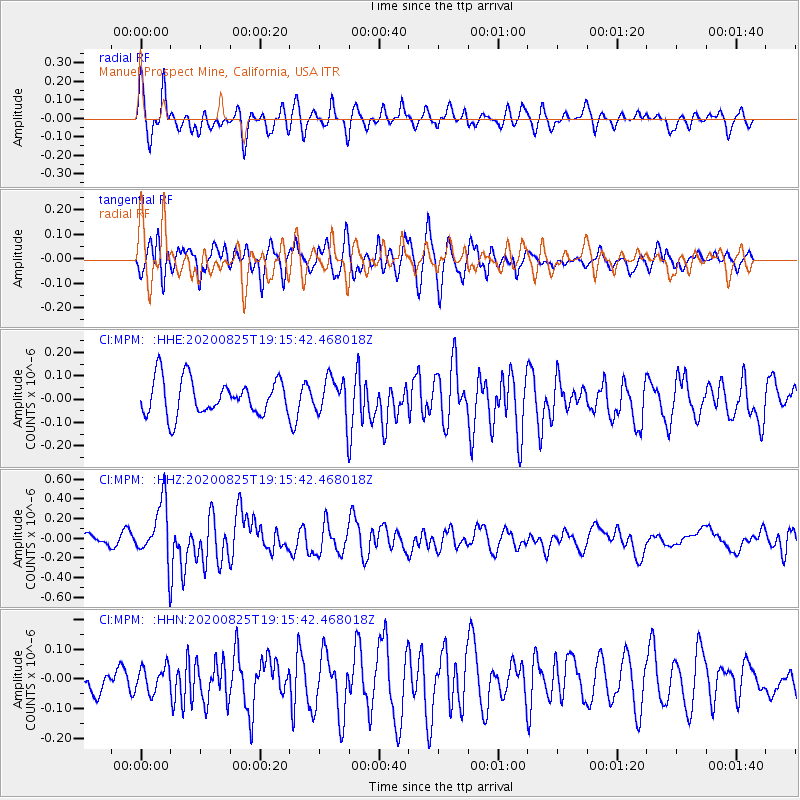
MPM Manuel Prospect Mine, California, USA - Earthquake Result Viewer
*The percent match for this event was below the threshold and hence no stack was calculated.
| Earthquake location: |
New Britain Region, P.N.G. |
| Earthquake latitude/longitude: |
-5.5/151.8 |
| Earthquake time(UTC): |
2020/08/25 (238) 19:02:59 GMT |
| Earthquake Depth: |
23 km |
| Earthquake Magnitude: |
5.7 Mww |
| Earthquake Catalog/Contributor: |
NEIC PDE/us |
|
| Network: |
CI Caltech Regional Seismic Network |
| Station: |
MPM Manuel Prospect Mine, California, USA |
| Lat/Lon: |
36.06 N/117.49 W |
| Elevation: |
185 m |
|
| Distance: |
93.8 deg |
| Az: |
54.292 deg |
| Baz: |
265.949 deg |
| Ray Param: |
$rayparam |
*The percent match for this event was below the threshold and hence was not used in the summary stack. |
|
| Radial Match: |
68.31552 % |
| Radial Bump: |
400 |
| Transverse Match: |
63.131847 % |
| Transverse Bump: |
400 |
| SOD ConfigId: |
21709731 |
| Insert Time: |
2020-09-08 19:11:23.108 +0000 |
| GWidth: |
2.5 |
| Max Bumps: |
400 |
| Tol: |
0.001 |
|
Signal To Noise
| Channel | StoN | STA | LTA |
| CI:MPM: :HHZ:20200825T19:15:42.468018Z | 4.5482163 | 2.947241E-7 | 6.4799934E-8 |
| CI:MPM: :HHN:20200825T19:15:42.468018Z | 0.5571546 | 4.1794646E-8 | 7.501445E-8 |
| CI:MPM: :HHE:20200825T19:15:42.468018Z | 1.111267 | 8.440635E-8 | 7.595506E-8 |
| Arrivals |
| Ps | |
| PpPs | |
| PsPs/PpSs | |


