You are here: Home > Network List > AU - Australian Seismological Centre Stations List
> Station WB2 Warramunga Array, NT > Earthquake Result Viewer
WB2 Warramunga Array, NT - Earthquake Result Viewer
| Earthquake location: |
Kermadec Islands Region |
| Earthquake latitude/longitude: |
-31.5/-178.8 |
| Earthquake time(UTC): |
2009/05/16 (136) 00:53:52 GMT |
| Earthquake Depth: |
55 km |
| Earthquake Magnitude: |
6.1 MB, 6.5 MW, 6.3 MW |
| Earthquake Catalog/Contributor: |
WHDF/NEIC |
|
| Network: |
AU Australian Seismological Centre |
| Station: |
WB2 Warramunga Array, NT |
| Lat/Lon: |
19.94 S/134.35 E |
| Elevation: |
425 m |
|
| Distance: |
43.5 deg |
| Az: |
273.759 deg |
| Baz: |
115.062 deg |
| Ray Param: |
0.07237737 |
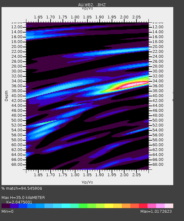
| Estimated Moho Depth: |
35.0 km |
| Estimated Crust Vp/Vs: |
2.05 |
| Assumed Crust Vp: |
6.642 km/s |
| Estimated Crust Vs: |
3.244 km/s |
| Estimated Crust Poisson's Ratio: |
0.34 |
|
| Radial Match: |
94.545906 % |
| Radial Bump: |
400 |
| Transverse Match: |
90.59414 % |
| Transverse Bump: |
400 |
| SOD ConfigId: |
2760 |
| Insert Time: |
2010-03-09 00:31:25.539 +0000 |
| GWidth: |
2.5 |
| Max Bumps: |
400 |
| Tol: |
0.001 |
|

Signal To Noise
| Channel | StoN | STA | LTA |
| AU:WB2: :BHZ:20090516T01:01:20.025004Z | 42.34425 | 8.700655E-6 | 2.0547431E-7 |
| AU:WB2: :BHN:20090516T01:01:20.025004Z | 1.8845628 | 6.925935E-7 | 3.6750882E-7 |
| AU:WB2: :BHE:20090516T01:01:20.025004Z | 15.257267 | 4.534132E-6 | 2.9717853E-7 |
| Arrivals |
| Ps | 5.9 SECOND |
| PpPs | 15 SECOND |
| PsPs/PpSs | 21 SECOND |


