You are here: Home > Network List > CN - Canadian National Seismograph Network Stations List
> Station DIB DAWSON INLET, BC > Earthquake Result Viewer
DIB DAWSON INLET, BC - Earthquake Result Viewer
| Earthquake location: |
New Britain Region, P.N.G. |
| Earthquake latitude/longitude: |
-5.5/151.8 |
| Earthquake time(UTC): |
2020/08/25 (238) 19:02:59 GMT |
| Earthquake Depth: |
23 km |
| Earthquake Magnitude: |
5.7 Mww |
| Earthquake Catalog/Contributor: |
NEIC PDE/us |
|
| Network: |
CN Canadian National Seismograph Network |
| Station: |
DIB DAWSON INLET, BC |
| Lat/Lon: |
53.20 N/132.48 W |
| Elevation: |
68 m |
|
| Distance: |
85.9 deg |
| Az: |
35.763 deg |
| Baz: |
255.253 deg |
| Ray Param: |
0.04441376 |
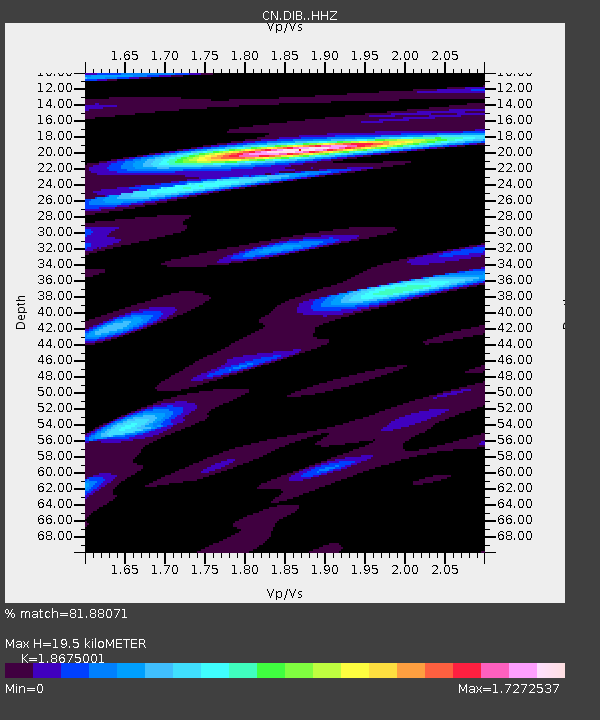
| Estimated Moho Depth: |
19.5 km |
| Estimated Crust Vp/Vs: |
1.87 |
| Assumed Crust Vp: |
6.183 km/s |
| Estimated Crust Vs: |
3.311 km/s |
| Estimated Crust Poisson's Ratio: |
0.30 |
|
| Radial Match: |
81.88071 % |
| Radial Bump: |
400 |
| Transverse Match: |
67.76932 % |
| Transverse Bump: |
400 |
| SOD ConfigId: |
21709731 |
| Insert Time: |
2020-09-08 19:12:16.995 +0000 |
| GWidth: |
2.5 |
| Max Bumps: |
400 |
| Tol: |
0.001 |
|

Signal To Noise
| Channel | StoN | STA | LTA |
| CN:DIB: :HHZ:20200825T19:15:05.559998Z | 11.254797 | 1.0924764E-6 | 9.706763E-8 |
| CN:DIB: :HHN:20200825T19:15:05.559998Z | 2.6624799 | 2.1855061E-7 | 8.208536E-8 |
| CN:DIB: :HHE:20200825T19:15:05.559998Z | 8.091299 | 3.8936795E-7 | 4.812181E-8 |
| Arrivals |
| Ps | 2.8 SECOND |
| PpPs | 8.9 SECOND |
| PsPs/PpSs | 12 SECOND |


