You are here: Home > Network List > TA - USArray Transportable Network (new EarthScope stations) Stations List
> Station A22K Sinclair Lake, AK, USA > Earthquake Result Viewer
A22K Sinclair Lake, AK, USA - Earthquake Result Viewer

| Earthquake location: |
New Britain Region, P.N.G. |
| Earthquake latitude/longitude: |
-5.5/151.8 |
| Earthquake time(UTC): |
2020/08/25 (238) 19:02:59 GMT |
| Earthquake Depth: |
23 km |
| Earthquake Magnitude: |
5.7 Mww |
| Earthquake Catalog/Contributor: |
NEIC PDE/us |
|
| Network: |
TA USArray Transportable Network (new EarthScope stations) |
| Station: |
A22K Sinclair Lake, AK, USA |
| Lat/Lon: |
71.00 N/154.97 W |
| Elevation: |
6.0 m |
|
| Distance: |
84.0 deg |
| Az: |
15.289 deg |
| Baz: |
233.278 deg |
| Ray Param: |
0.045778465 |
| Estimated Moho Depth: |
54.0 km |
| Estimated Crust Vp/Vs: |
1.73 |
| Assumed Crust Vp: |
5.782 km/s |
| Estimated Crust Vs: |
3.347 km/s |
| Estimated Crust Poisson's Ratio: |
0.25 |
|
| Radial Match: |
88.26193 % |
| Radial Bump: |
321 |
| Transverse Match: |
88.91374 % |
| Transverse Bump: |
324 |
| SOD ConfigId: |
21709731 |
| Insert Time: |
2020-09-08 19:17:52.675 +0000 |
| GWidth: |
2.5 |
| Max Bumps: |
400 |
| Tol: |
0.001 |
|
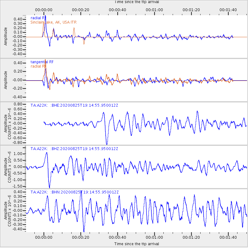
Signal To Noise
| Channel | StoN | STA | LTA |
| TA:A22K: :BHZ:20200825T19:14:55.950012Z | 13.544134 | 7.9926303E-7 | 5.9011747E-8 |
| TA:A22K: :BHN:20200825T19:14:55.950012Z | 2.5605388 | 1.643193E-7 | 6.417372E-8 |
| TA:A22K: :BHE:20200825T19:14:55.950012Z | 10.24757 | 4.116162E-7 | 4.01672E-8 |
| Arrivals |
| Ps | 6.9 SECOND |
| PpPs | 25 SECOND |
| PsPs/PpSs | 32 SECOND |


