You are here: Home > Network List > TA - USArray Transportable Network (new EarthScope stations) Stations List
> Station E21K Killik River, AK, USA > Earthquake Result Viewer
E21K Killik River, AK, USA - Earthquake Result Viewer
| Earthquake location: |
New Britain Region, P.N.G. |
| Earthquake latitude/longitude: |
-5.5/151.8 |
| Earthquake time(UTC): |
2020/08/25 (238) 19:02:59 GMT |
| Earthquake Depth: |
23 km |
| Earthquake Magnitude: |
5.7 Mww |
| Earthquake Catalog/Contributor: |
NEIC PDE/us |
|
| Network: |
TA USArray Transportable Network (new EarthScope stations) |
| Station: |
E21K Killik River, AK, USA |
| Lat/Lon: |
68.44 N/153.97 W |
| Elevation: |
653 m |
|
| Distance: |
82.7 deg |
| Az: |
17.591 deg |
| Baz: |
234.483 deg |
| Ray Param: |
0.04665503 |
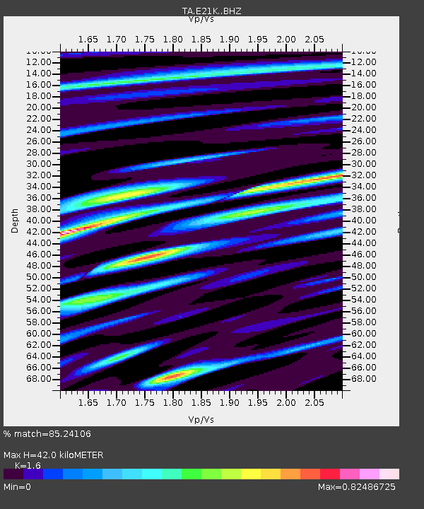
| Estimated Moho Depth: |
42.0 km |
| Estimated Crust Vp/Vs: |
1.60 |
| Assumed Crust Vp: |
6.221 km/s |
| Estimated Crust Vs: |
3.888 km/s |
| Estimated Crust Poisson's Ratio: |
0.18 |
|
| Radial Match: |
85.24106 % |
| Radial Bump: |
400 |
| Transverse Match: |
89.92239 % |
| Transverse Bump: |
400 |
| SOD ConfigId: |
21709731 |
| Insert Time: |
2020-09-08 19:18:31.081 +0000 |
| GWidth: |
2.5 |
| Max Bumps: |
400 |
| Tol: |
0.001 |
|

Signal To Noise
| Channel | StoN | STA | LTA |
| TA:E21K: :BHZ:20200825T19:14:49.625Z | 16.919174 | 7.0991734E-7 | 4.195934E-8 |
| TA:E21K: :BHN:20200825T19:14:49.625Z | 4.460729 | 1.0581193E-7 | 2.372077E-8 |
| TA:E21K: :BHE:20200825T19:14:49.625Z | 7.8291407 | 1.8717978E-7 | 2.3908088E-8 |
| Arrivals |
| Ps | 4.2 SECOND |
| PpPs | 17 SECOND |
| PsPs/PpSs | 21 SECOND |


