You are here: Home > Network List > TA - USArray Transportable Network (new EarthScope stations) Stations List
> Station F20K Avaraart Lake, AK, USA > Earthquake Result Viewer
F20K Avaraart Lake, AK, USA - Earthquake Result Viewer
| Earthquake location: |
New Britain Region, P.N.G. |
| Earthquake latitude/longitude: |
-5.5/151.8 |
| Earthquake time(UTC): |
2020/08/25 (238) 19:02:59 GMT |
| Earthquake Depth: |
23 km |
| Earthquake Magnitude: |
5.7 Mww |
| Earthquake Catalog/Contributor: |
NEIC PDE/us |
|
| Network: |
TA USArray Transportable Network (new EarthScope stations) |
| Station: |
F20K Avaraart Lake, AK, USA |
| Lat/Lon: |
67.05 N/155.73 W |
| Elevation: |
136 m |
|
| Distance: |
81.4 deg |
| Az: |
18.331 deg |
| Baz: |
232.965 deg |
| Ray Param: |
0.047609843 |
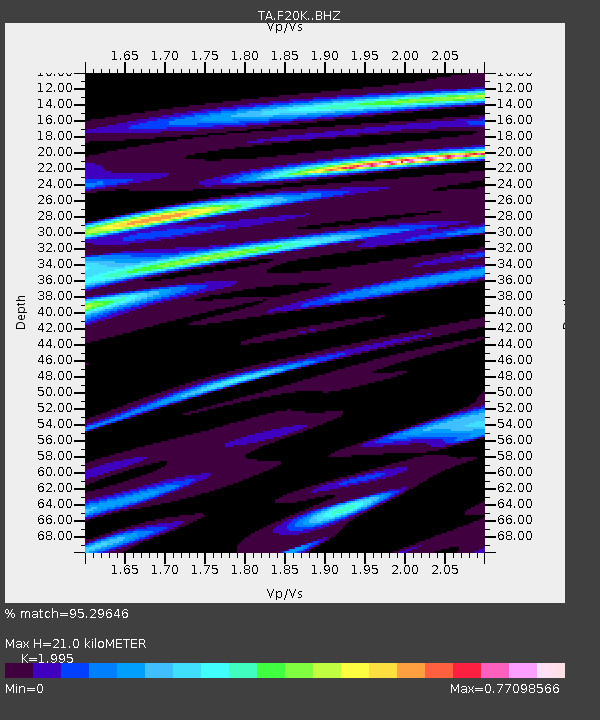
| Estimated Moho Depth: |
21.0 km |
| Estimated Crust Vp/Vs: |
2.00 |
| Assumed Crust Vp: |
6.522 km/s |
| Estimated Crust Vs: |
3.269 km/s |
| Estimated Crust Poisson's Ratio: |
0.33 |
|
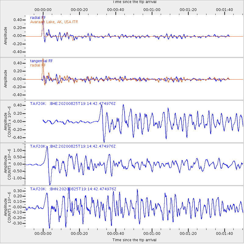
| Radial Match: |
95.29646 % |
| Radial Bump: |
386 |
| Transverse Match: |
85.096466 % |
| Transverse Bump: |
400 |
| SOD ConfigId: |
21709731 |
| Insert Time: |
2020-09-08 19:18:50.587 +0000 |
| GWidth: |
2.5 |
| Max Bumps: |
400 |
| Tol: |
0.001 |
|
Signal To Noise
| Channel | StoN | STA | LTA |
| TA:F20K: :BHZ:20200825T19:14:42.474976Z | 28.779106 | 8.1704206E-7 | 2.8390113E-8 |
| TA:F20K: :BHN:20200825T19:14:42.474976Z | 7.6653113 | 1.7939418E-7 | 2.3403379E-8 |
| TA:F20K: :BHE:20200825T19:14:42.474976Z | 10.633256 | 2.5555195E-7 | 2.4033273E-8 |
| Arrivals |
| Ps | 3.3 SECOND |
| PpPs | 9.4 SECOND |
| PsPs/PpSs | 13 SECOND |


