You are here: Home > Network List > TA - USArray Transportable Network (new EarthScope stations) Stations List
> Station M31M Drury Creek, Yukon, CA > Earthquake Result Viewer
M31M Drury Creek, Yukon, CA - Earthquake Result Viewer
| Earthquake location: |
New Britain Region, P.N.G. |
| Earthquake latitude/longitude: |
-5.5/151.8 |
| Earthquake time(UTC): |
2020/08/25 (238) 19:02:59 GMT |
| Earthquake Depth: |
23 km |
| Earthquake Magnitude: |
5.7 Mww |
| Earthquake Catalog/Contributor: |
NEIC PDE/us |
|
| Network: |
TA USArray Transportable Network (new EarthScope stations) |
| Station: |
M31M Drury Creek, Yukon, CA |
| Lat/Lon: |
62.20 N/134.39 W |
| Elevation: |
639 m |
|
| Distance: |
87.4 deg |
| Az: |
26.785 deg |
| Baz: |
253.106 deg |
| Ray Param: |
0.043346986 |
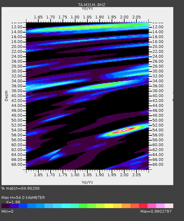
| Estimated Moho Depth: |
54.0 km |
| Estimated Crust Vp/Vs: |
1.99 |
| Assumed Crust Vp: |
6.419 km/s |
| Estimated Crust Vs: |
3.226 km/s |
| Estimated Crust Poisson's Ratio: |
0.33 |
|
| Radial Match: |
84.98288 % |
| Radial Bump: |
400 |
| Transverse Match: |
82.73434 % |
| Transverse Bump: |
400 |
| SOD ConfigId: |
21709731 |
| Insert Time: |
2020-09-08 19:20:06.980 +0000 |
| GWidth: |
2.5 |
| Max Bumps: |
400 |
| Tol: |
0.001 |
|

Signal To Noise
| Channel | StoN | STA | LTA |
| TA:M31M: :BHZ:20200825T19:15:12.750Z | 14.081699 | 7.0924636E-7 | 5.036653E-8 |
| TA:M31M: :BHN:20200825T19:15:12.750Z | 3.8488426 | 1.1342028E-7 | 2.9468671E-8 |
| TA:M31M: :BHE:20200825T19:15:12.750Z | 6.534563 | 1.8419404E-7 | 2.818766E-8 |
| Arrivals |
| Ps | 8.5 SECOND |
| PpPs | 25 SECOND |
| PsPs/PpSs | 33 SECOND |


