You are here: Home > Network List > TA - USArray Transportable Network (new EarthScope stations) Stations List
> Station O16K Kokwok River, Bristol Bay, AK, USA > Earthquake Result Viewer
O16K Kokwok River, Bristol Bay, AK, USA - Earthquake Result Viewer
| Earthquake location: |
New Britain Region, P.N.G. |
| Earthquake latitude/longitude: |
-5.5/151.8 |
| Earthquake time(UTC): |
2020/08/25 (238) 19:02:59 GMT |
| Earthquake Depth: |
23 km |
| Earthquake Magnitude: |
5.7 Mww |
| Earthquake Catalog/Contributor: |
NEIC PDE/us |
|
| Network: |
TA USArray Transportable Network (new EarthScope stations) |
| Station: |
O16K Kokwok River, Bristol Bay, AK, USA |
| Lat/Lon: |
59.59 N/158.09 W |
| Elevation: |
198 m |
|
| Distance: |
76.0 deg |
| Az: |
23.713 deg |
| Baz: |
231.906 deg |
| Ray Param: |
0.051290605 |
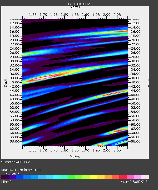
| Estimated Moho Depth: |
37.75 km |
| Estimated Crust Vp/Vs: |
1.70 |
| Assumed Crust Vp: |
6.24 km/s |
| Estimated Crust Vs: |
3.681 km/s |
| Estimated Crust Poisson's Ratio: |
0.23 |
|
| Radial Match: |
88.142 % |
| Radial Bump: |
400 |
| Transverse Match: |
77.79869 % |
| Transverse Bump: |
400 |
| SOD ConfigId: |
21709731 |
| Insert Time: |
2020-09-08 19:20:20.538 +0000 |
| GWidth: |
2.5 |
| Max Bumps: |
400 |
| Tol: |
0.001 |
|

Signal To Noise
| Channel | StoN | STA | LTA |
| TA:O16K: :BHZ:20200825T19:14:12.799988Z | 8.675648 | 6.10349E-7 | 7.035198E-8 |
| TA:O16K: :BHN:20200825T19:14:12.799988Z | 4.6203885 | 2.0214337E-7 | 4.3750298E-8 |
| TA:O16K: :BHE:20200825T19:14:12.799988Z | 3.003544 | 1.655959E-7 | 5.51335E-8 |
| Arrivals |
| Ps | 4.3 SECOND |
| PpPs | 16 SECOND |
| PsPs/PpSs | 20 SECOND |


