You are here: Home > Network List > TA - USArray Transportable Network (new EarthScope stations) Stations List
> Station G31M Satah River, YT, CAN > Earthquake Result Viewer
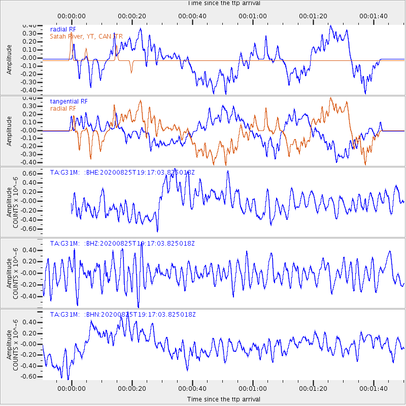
G31M Satah River, YT, CAN - Earthquake Result Viewer
*The percent match for this event was below the threshold and hence no stack was calculated.
| Earthquake location: |
New Britain Region, P.N.G. |
| Earthquake latitude/longitude: |
-5.6/151.8 |
| Earthquake time(UTC): |
2020/08/25 (238) 19:04:41 GMT |
| Earthquake Depth: |
10 km |
| Earthquake Magnitude: |
5.5 mb |
| Earthquake Catalog/Contributor: |
NEIC PDE/us |
|
| Network: |
TA USArray Transportable Network (new EarthScope stations) |
| Station: |
G31M Satah River, YT, CAN |
| Lat/Lon: |
66.92 N/134.27 W |
| Elevation: |
61 m |
|
| Distance: |
88.8 deg |
| Az: |
22.26 deg |
| Baz: |
253.033 deg |
| Ray Param: |
$rayparam |
*The percent match for this event was below the threshold and hence was not used in the summary stack. |
|
| Radial Match: |
41.46998 % |
| Radial Bump: |
400 |
| Transverse Match: |
40.65389 % |
| Transverse Bump: |
400 |
| SOD ConfigId: |
21709731 |
| Insert Time: |
2020-09-08 19:32:13.108 +0000 |
| GWidth: |
2.5 |
| Max Bumps: |
400 |
| Tol: |
0.001 |
|
Signal To Noise
| Channel | StoN | STA | LTA |
| TA:G31M: :BHZ:20200825T19:17:03.825018Z | 1.0124048 | 2.3772283E-7 | 2.3481006E-7 |
| TA:G31M: :BHN:20200825T19:17:03.825018Z | 0.64859366 | 1.6761146E-7 | 2.584229E-7 |
| TA:G31M: :BHE:20200825T19:17:03.825018Z | 3.6994362 | 6.1914744E-7 | 1.6736264E-7 |
| Arrivals |
| Ps | |
| PpPs | |
| PsPs/PpSs | |


