You are here: Home > Network List > AU - Australian Seismological Centre Stations List
> Station XMI Christmas Island Airport, Australia > Earthquake Result Viewer
XMI Christmas Island Airport, Australia - Earthquake Result Viewer
| Earthquake location: |
Hokkaido, Japan Region |
| Earthquake latitude/longitude: |
41.9/143.8 |
| Earthquake time(UTC): |
2008/09/11 (255) 00:20:50 GMT |
| Earthquake Depth: |
25 km |
| Earthquake Magnitude: |
6.1 MB, 7.0 MS, 6.8 MW, 6.8 MW |
| Earthquake Catalog/Contributor: |
WHDF/NEIC |
|
| Network: |
AU Australian Seismological Centre |
| Station: |
XMI Christmas Island Airport, Australia |
| Lat/Lon: |
10.45 S/105.69 E |
| Elevation: |
278 m |
|
| Distance: |
62.7 deg |
| Az: |
223.027 deg |
| Baz: |
31.194 deg |
| Ray Param: |
0.060007762 |
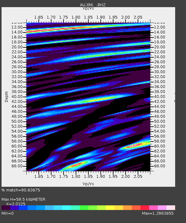
| Estimated Moho Depth: |
59.5 km |
| Estimated Crust Vp/Vs: |
2.03 |
| Assumed Crust Vp: |
4.157 km/s |
| Estimated Crust Vs: |
2.045 km/s |
| Estimated Crust Poisson's Ratio: |
0.34 |
|
| Radial Match: |
90.63675 % |
| Radial Bump: |
385 |
| Transverse Match: |
60.701305 % |
| Transverse Bump: |
400 |
| SOD ConfigId: |
2560 |
| Insert Time: |
2010-03-09 00:33:25.292 +0000 |
| GWidth: |
2.5 |
| Max Bumps: |
400 |
| Tol: |
0.001 |
|

Signal To Noise
| Channel | StoN | STA | LTA |
| AU:XMI: :BHZ:20080911T00:30:42.719011Z | 3.1916854 | 1.2684675E-6 | 3.9742875E-7 |
| AU:XMI: :BHN:20080911T00:30:42.719011Z | 1.4653523 | 6.841997E-7 | 4.669182E-7 |
| AU:XMI: :BHE:20080911T00:30:42.719011Z | 1.4961804 | 8.041034E-7 | 5.374375E-7 |
| Arrivals |
| Ps | 15 SECOND |
| PpPs | 43 SECOND |
| PsPs/PpSs | 58 SECOND |


