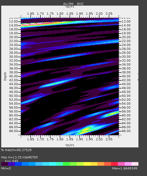
XMI Christmas Island Airport - Earthquake Result Viewer

Earthquake location: Ryukyu Islands, Japan
Earthquake latitude/longitude: 29.2/129.8
Earthquake time(UTC): 2009/10/30 (303) 07:03:39 GMT
Earthquake Depth: 34 km
Earthquake Magnitude: 6.3 MB, 6.8 MS, 6.8 MW, 6.8 MW
Earthquake Catalog/Contributor: WHDF/NEIC
Network: AU Australian Seismological Centre
Station: XMI Christmas Island Airport
Lat/Lon: 10.45 S/105.69 E
Elevation: 252 m
Distance: 45.8 deg
Az: 214.077 deg
Baz: 29.864 deg
Ray Param: 0.07098616
Estimated Moho Depth: 13.25 km
Estimated Crust Vp/Vs: 1.64
Assumed Crust Vp: 4.157 km/s
Estimated Crust Vs: 2.527 km/s
Estimated Crust Poisson's Ratio: 0.21
Radial Match: 85.37529 %
Radial Bump: 400
Transverse Match: 76.38414 %
Transverse Bump: 400
SOD ConfigId: 2622
Insert Time: 2010-03-09 00:33:32.678 +0000
GWidth: 2.5
Max Bumps: 400
Tol: 0.001

Signal To Noise

ChannelStoNSTALTA
AU:XMI: :BHZ:20091030T07:11:26.893987Z6.4367014.1328863E-66.420815E-7
AU:XMI: :BHN:20091030T07:11:26.893987Z2.59837632.24448E-68.6380095E-7
AU:XMI: :BHE:20091030T07:11:26.893987Z2.97640421.8061662E-66.068283E-7
Arrivals
Ps2.1 SECOND
PpPs8.2 SECOND
PsPs/PpSs10 SECOND