You are here: Home > Network List > AK - Alaska Regional Network Stations List
> Station PS06 TAPS Pump Station 6, AK, USA > Earthquake Result Viewer
PS06 TAPS Pump Station 6, AK, USA - Earthquake Result Viewer
| Earthquake location: |
New Britain Region, P.N.G. |
| Earthquake latitude/longitude: |
-5.5/151.8 |
| Earthquake time(UTC): |
2020/08/25 (238) 19:08:53 GMT |
| Earthquake Depth: |
24 km |
| Earthquake Magnitude: |
6.1 mww |
| Earthquake Catalog/Contributor: |
NEIC PDE/us |
|
| Network: |
AK Alaska Regional Network |
| Station: |
PS06 TAPS Pump Station 6, AK, USA |
| Lat/Lon: |
65.85 N/149.74 W |
| Elevation: |
280 m |
|
| Distance: |
82.7 deg |
| Az: |
20.692 deg |
| Baz: |
238.771 deg |
| Ray Param: |
0.046711817 |
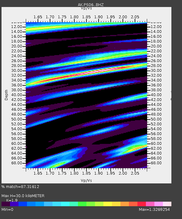
| Estimated Moho Depth: |
30.0 km |
| Estimated Crust Vp/Vs: |
1.90 |
| Assumed Crust Vp: |
6.566 km/s |
| Estimated Crust Vs: |
3.456 km/s |
| Estimated Crust Poisson's Ratio: |
0.31 |
|
| Radial Match: |
87.31612 % |
| Radial Bump: |
364 |
| Transverse Match: |
78.84722 % |
| Transverse Bump: |
400 |
| SOD ConfigId: |
21709731 |
| Insert Time: |
2020-09-08 19:37:01.423 +0000 |
| GWidth: |
2.5 |
| Max Bumps: |
400 |
| Tol: |
0.001 |
|

Signal To Noise
| Channel | StoN | STA | LTA |
| AK:PS06: :BHZ:20200825T19:20:43.68803Z | 11.822014 | 5.9874134E-7 | 5.0646307E-8 |
| AK:PS06: :BHN:20200825T19:20:43.68803Z | 4.340501 | 2.5091444E-7 | 5.7807718E-8 |
| AK:PS06: :BHE:20200825T19:20:43.68803Z | 5.06199 | 3.2196502E-7 | 6.360444E-8 |
| Arrivals |
| Ps | 4.2 SECOND |
| PpPs | 13 SECOND |
| PsPs/PpSs | 17 SECOND |


