You are here: Home > Network List > AK - Alaska Regional Network Stations List
> Station PS07 TAPS Pump Station 7, AK, USA > Earthquake Result Viewer
PS07 TAPS Pump Station 7, AK, USA - Earthquake Result Viewer
| Earthquake location: |
New Britain Region, P.N.G. |
| Earthquake latitude/longitude: |
-5.5/151.8 |
| Earthquake time(UTC): |
2020/08/25 (238) 19:08:53 GMT |
| Earthquake Depth: |
24 km |
| Earthquake Magnitude: |
6.1 mww |
| Earthquake Catalog/Contributor: |
NEIC PDE/us |
|
| Network: |
AK Alaska Regional Network |
| Station: |
PS07 TAPS Pump Station 7, AK, USA |
| Lat/Lon: |
65.31 N/148.28 W |
| Elevation: |
289 m |
|
| Distance: |
82.9 deg |
| Az: |
21.477 deg |
| Baz: |
240.196 deg |
| Ray Param: |
0.046540845 |
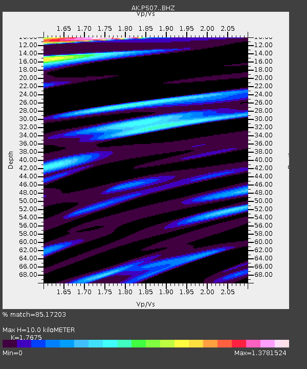
| Estimated Moho Depth: |
10.0 km |
| Estimated Crust Vp/Vs: |
1.77 |
| Assumed Crust Vp: |
6.566 km/s |
| Estimated Crust Vs: |
3.715 km/s |
| Estimated Crust Poisson's Ratio: |
0.26 |
|
| Radial Match: |
85.17203 % |
| Radial Bump: |
400 |
| Transverse Match: |
74.168945 % |
| Transverse Bump: |
400 |
| SOD ConfigId: |
21709731 |
| Insert Time: |
2020-09-08 19:37:03.603 +0000 |
| GWidth: |
2.5 |
| Max Bumps: |
400 |
| Tol: |
0.001 |
|

Signal To Noise
| Channel | StoN | STA | LTA |
| AK:PS07: :BHZ:20200825T19:20:44.947979Z | 11.932391 | 9.026748E-7 | 7.564912E-8 |
| AK:PS07: :BHN:20200825T19:20:44.947979Z | 1.951484 | 1.9937907E-7 | 1.0216793E-7 |
| AK:PS07: :BHE:20200825T19:20:44.947979Z | 4.740066 | 3.5065423E-7 | 7.397665E-8 |
| Arrivals |
| Ps | 1.2 SECOND |
| PpPs | 4.1 SECOND |
| PsPs/PpSs | 5.3 SECOND |


