You are here: Home > Network List > IU - Global Seismograph Network (GSN - IRIS/USGS) Stations List
> Station CTAO Charters Towers, Australia > Earthquake Result Viewer
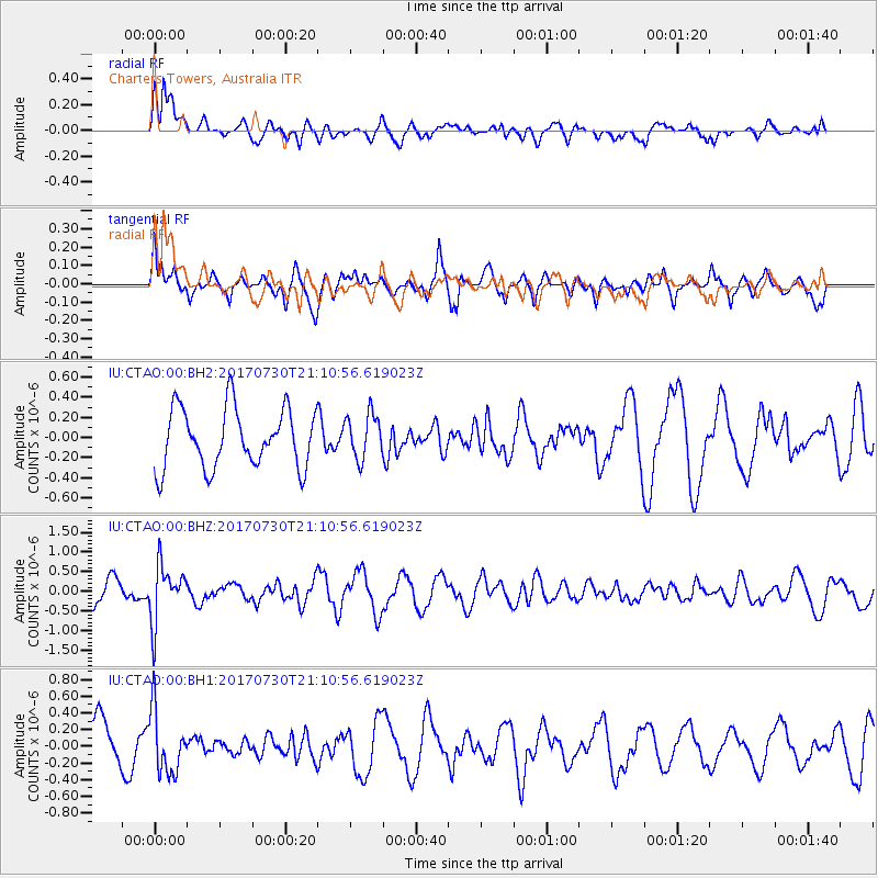
CTAO Charters Towers, Australia - Earthquake Result Viewer
*The percent match for this event was below the threshold and hence no stack was calculated.
| Earthquake location: |
Kuril Islands |
| Earthquake latitude/longitude: |
46.2/151.0 |
| Earthquake time(UTC): |
2017/07/30 (211) 21:00:49 GMT |
| Earthquake Depth: |
87 km |
| Earthquake Magnitude: |
5.7 mb |
| Earthquake Catalog/Contributor: |
NEIC PDE/us |
|
| Network: |
IU Global Seismograph Network (GSN - IRIS/USGS) |
| Station: |
CTAO Charters Towers, Australia |
| Lat/Lon: |
20.09 S/146.25 E |
| Elevation: |
357 m |
|
| Distance: |
66.1 deg |
| Az: |
184.83 deg |
| Baz: |
3.567 deg |
| Ray Param: |
$rayparam |
*The percent match for this event was below the threshold and hence was not used in the summary stack. |
|
| Radial Match: |
51.22539 % |
| Radial Bump: |
400 |
| Transverse Match: |
48.931396 % |
| Transverse Bump: |
400 |
| SOD ConfigId: |
2140511 |
| Insert Time: |
2017-08-13 12:57:14.307 +0000 |
| GWidth: |
2.5 |
| Max Bumps: |
400 |
| Tol: |
0.001 |
|
Signal To Noise
| Channel | StoN | STA | LTA |
| IU:CTAO:00:BHZ:20170730T21:10:56.619023Z | 2.1975882 | 7.209108E-7 | 3.2804635E-7 |
| IU:CTAO:00:BH1:20170730T21:10:56.619023Z | 1.0270367 | 3.6764885E-7 | 3.579705E-7 |
| IU:CTAO:00:BH2:20170730T21:10:56.619023Z | 0.7585436 | 2.2262438E-7 | 2.9348922E-7 |
| Arrivals |
| Ps | |
| PpPs | |
| PsPs/PpSs | |


