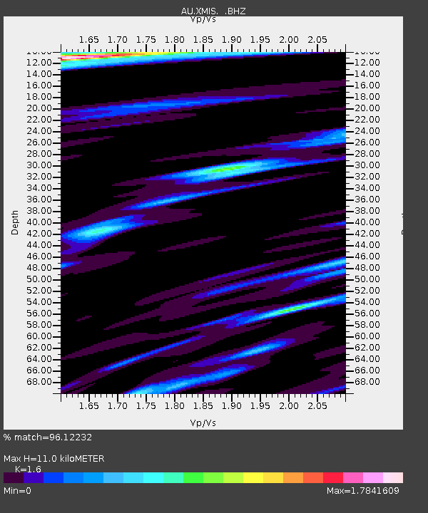
XMIS Christmas Island Grants Well - Earthquake Result Viewer

Earthquake location: Tonga Islands
Earthquake latitude/longitude: -21.9/-173.8
Earthquake time(UTC): 2008/10/19 (293) 05:10:33 GMT
Earthquake Depth: 29 km
Earthquake Magnitude: 6.8 MB, 7.0 MS, 6.9 MW, 6.9 MW
Earthquake Catalog/Contributor: WHDF/NEIC
Network: AU Australian Seismological Centre
Station: XMIS Christmas Island Grants Well
Lat/Lon: 10.48 S/105.65 E
Elevation: 210 m
Distance: 77.5 deg
Az: 263.65 deg
Baz: 110.167 deg
Ray Param: 0.05027485
Estimated Moho Depth: 11.0 km
Estimated Crust Vp/Vs: 1.60
Assumed Crust Vp: 4.157 km/s
Estimated Crust Vs: 2.598 km/s
Estimated Crust Poisson's Ratio: 0.18
Radial Match: 96.12232 %
Radial Bump: 400
Transverse Match: 85.326836 %
Transverse Bump: 400
SOD ConfigId: 2560
Insert Time: 2010-03-09 00:34:25.518 +0000
GWidth: 2.5
Max Bumps: 400
Tol: 0.001

Signal To Noise

ChannelStoNSTALTA
AU:XMIS: :BHZ:20081019T05:21:55.269009Z19.567117.398426E-63.7810517E-7
AU:XMIS: :BHN:20081019T05:21:55.269009Z2.0396881.1403546E-65.5908276E-7
AU:XMIS: :BHE:20081019T05:21:55.269009Z6.1578043.5059868E-65.6935664E-7
Arrivals
Ps1.6 SECOND
PpPs6.8 SECOND
PsPs/PpSs8.4 SECOND