You are here: Home > Network List > IU - Global Seismograph Network (GSN - IRIS/USGS) Stations List
> Station SFJD Sondre Stromfjord, Greenland > Earthquake Result Viewer
SFJD Sondre Stromfjord, Greenland - Earthquake Result Viewer
| Earthquake location: |
Kuril Islands |
| Earthquake latitude/longitude: |
46.2/151.0 |
| Earthquake time(UTC): |
2017/07/30 (211) 21:00:49 GMT |
| Earthquake Depth: |
87 km |
| Earthquake Magnitude: |
5.7 mb |
| Earthquake Catalog/Contributor: |
NEIC PDE/us |
|
| Network: |
IU Global Seismograph Network (GSN - IRIS/USGS) |
| Station: |
SFJD Sondre Stromfjord, Greenland |
| Lat/Lon: |
67.00 N/50.62 W |
| Elevation: |
330 m |
|
| Distance: |
65.9 deg |
| Az: |
9.107 deg |
| Baz: |
343.76 deg |
| Ray Param: |
0.05772844 |
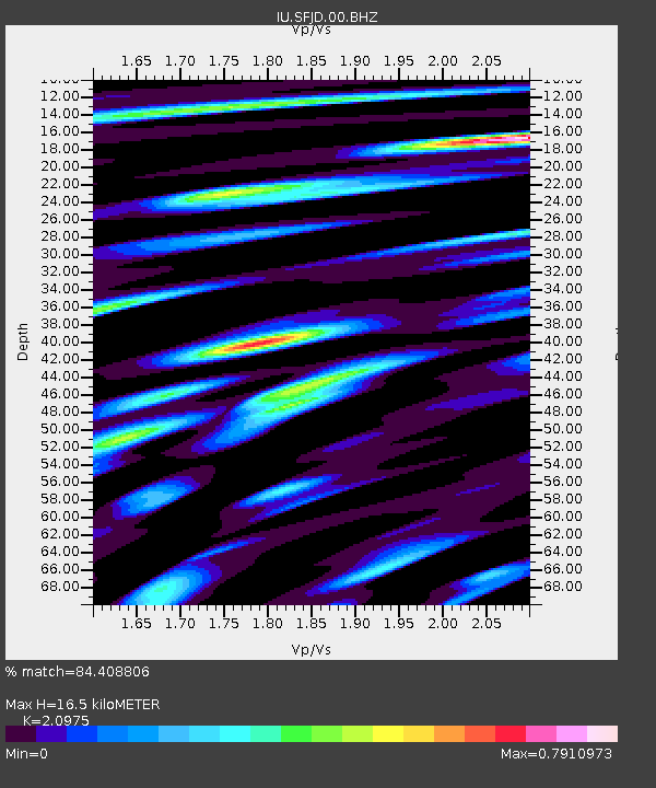
| Estimated Moho Depth: |
16.5 km |
| Estimated Crust Vp/Vs: |
2.10 |
| Assumed Crust Vp: |
6.459 km/s |
| Estimated Crust Vs: |
3.08 km/s |
| Estimated Crust Poisson's Ratio: |
0.35 |
|
| Radial Match: |
84.408806 % |
| Radial Bump: |
400 |
| Transverse Match: |
61.23089 % |
| Transverse Bump: |
400 |
| SOD ConfigId: |
2140511 |
| Insert Time: |
2017-08-13 12:57:50.420 +0000 |
| GWidth: |
2.5 |
| Max Bumps: |
400 |
| Tol: |
0.001 |
|
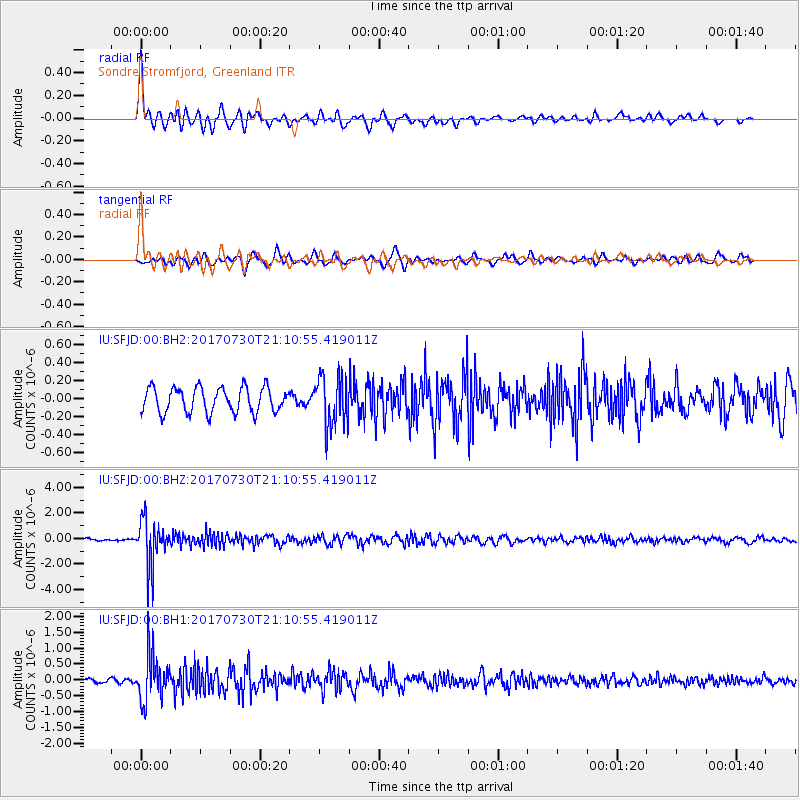
Signal To Noise
| Channel | StoN | STA | LTA |
| IU:SFJD:00:BHZ:20170730T21:10:55.419011Z | 16.404205 | 1.757646E-6 | 1.0714606E-7 |
| IU:SFJD:00:BH1:20170730T21:10:55.419011Z | 11.042268 | 7.294975E-7 | 6.60641E-8 |
| IU:SFJD:00:BH2:20170730T21:10:55.419011Z | 2.0088108 | 2.7462877E-7 | 1.3671212E-7 |
| Arrivals |
| Ps | 2.9 SECOND |
| PpPs | 7.6 SECOND |
| PsPs/PpSs | 11 SECOND |


