You are here: Home > Network List > CI - Caltech Regional Seismic Network Stations List
> Station MPM Manuel Prospect Mine, California, USA > Earthquake Result Viewer
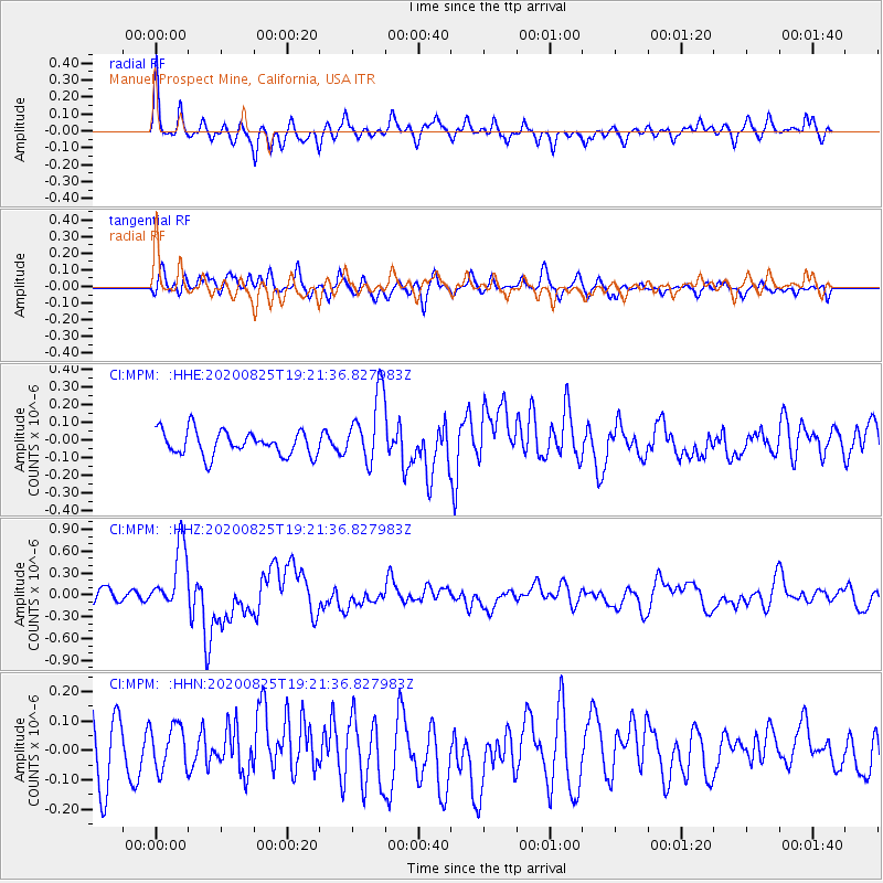
MPM Manuel Prospect Mine, California, USA - Earthquake Result Viewer
*The percent match for this event was below the threshold and hence no stack was calculated.
| Earthquake location: |
New Britain Region, P.N.G. |
| Earthquake latitude/longitude: |
-5.5/151.8 |
| Earthquake time(UTC): |
2020/08/25 (238) 19:08:53 GMT |
| Earthquake Depth: |
24 km |
| Earthquake Magnitude: |
6.1 mww |
| Earthquake Catalog/Contributor: |
NEIC PDE/us |
|
| Network: |
CI Caltech Regional Seismic Network |
| Station: |
MPM Manuel Prospect Mine, California, USA |
| Lat/Lon: |
36.06 N/117.49 W |
| Elevation: |
185 m |
|
| Distance: |
93.7 deg |
| Az: |
54.289 deg |
| Baz: |
265.966 deg |
| Ray Param: |
$rayparam |
*The percent match for this event was below the threshold and hence was not used in the summary stack. |
|
| Radial Match: |
71.74765 % |
| Radial Bump: |
400 |
| Transverse Match: |
51.560482 % |
| Transverse Bump: |
400 |
| SOD ConfigId: |
21709731 |
| Insert Time: |
2020-09-08 19:42:07.292 +0000 |
| GWidth: |
2.5 |
| Max Bumps: |
400 |
| Tol: |
0.001 |
|
Signal To Noise
| Channel | StoN | STA | LTA |
| CI:MPM: :HHZ:20200825T19:21:36.827983Z | 4.191225 | 4.4421643E-7 | 1.05987255E-7 |
| CI:MPM: :HHN:20200825T19:21:36.827983Z | 0.93018526 | 7.9214814E-8 | 8.516025E-8 |
| CI:MPM: :HHE:20200825T19:21:36.827983Z | 2.858239 | 1.9843651E-7 | 6.942614E-8 |
| Arrivals |
| Ps | |
| PpPs | |
| PsPs/PpSs | |


