You are here: Home > Network List > AU - Australian Seismological Centre Stations List
> Station XMIS Christmas Island, Australia > Earthquake Result Viewer
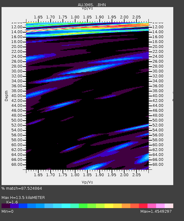
XMIS Christmas Island, Australia - Earthquake Result Viewer
| Earthquake location: |
Southeast Indian Ridge |
| Earthquake latitude/longitude: |
-45.2/96.9 |
| Earthquake time(UTC): |
2005/10/29 (302) 04:05:56 GMT |
| Earthquake Depth: |
8.0 km |
| Earthquake Magnitude: |
6.1 MB, 6.2 MS, 6.5 MW, 6.4 MW |
| Earthquake Catalog/Contributor: |
WHDF/NEIC |
|
| Network: |
AU Australian Seismological Centre |
| Station: |
XMIS Christmas Island, Australia |
| Lat/Lon: |
10.48 S/105.65 E |
| Elevation: |
245 m |
|
| Distance: |
35.4 deg |
| Az: |
14.968 deg |
| Baz: |
190.698 deg |
| Ray Param: |
0.07723928 |
| Estimated Moho Depth: |
13.5 km |
| Estimated Crust Vp/Vs: |
1.60 |
| Assumed Crust Vp: |
4.157 km/s |
| Estimated Crust Vs: |
2.598 km/s |
| Estimated Crust Poisson's Ratio: |
0.18 |
|
| Radial Match: |
87.524864 % |
| Radial Bump: |
265 |
| Transverse Match: |
67.96067 % |
| Transverse Bump: |
400 |
| SOD ConfigId: |
2564 |
| Insert Time: |
2010-03-09 00:34:39.735 +0000 |
| GWidth: |
2.5 |
| Max Bumps: |
400 |
| Tol: |
0.001 |
|

Signal To Noise
| Channel | StoN | STA | LTA |
| AU:XMIS: :BHN:20051029T04:12:21.670005Z | 3.0441656 | 2.7278412E-12 | 8.9608827E-13 |
| AU:XMIS: :BHE:20051029T04:12:21.670005Z | 1.4795158 | 1.3256782E-12 | 8.960216E-13 |
| AU:XMIS: :BHZ:20051029T04:12:21.670005Z | 3.3544133 | 2.8879837E-12 | 8.6095047E-13 |
| Arrivals |
| Ps | 2.0 SECOND |
| PpPs | 8.2 SECOND |
| PsPs/PpSs | 10 SECOND |


