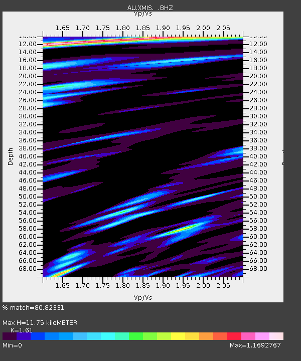
XMIS Christmas Island Grants Well - Earthquake Result Viewer

Earthquake location: Qinghai, China
Earthquake latitude/longitude: 37.6/95.8
Earthquake time(UTC): 2008/11/10 (315) 01:22:02 GMT
Earthquake Depth: 19 km
Earthquake Magnitude: 6.4 MB, 6.4 MS, 6.3 MW, 6.3 MW
Earthquake Catalog/Contributor: WHDF/NEIC
Network: AU Australian Seismological Centre
Station: XMIS Christmas Island Grants Well
Lat/Lon: 10.48 S/105.65 E
Elevation: 210 m
Distance: 48.7 deg
Az: 167.093 deg
Baz: 349.603 deg
Ray Param: 0.069182776
Estimated Moho Depth: 11.75 km
Estimated Crust Vp/Vs: 1.61
Assumed Crust Vp: 4.157 km/s
Estimated Crust Vs: 2.582 km/s
Estimated Crust Poisson's Ratio: 0.19
Radial Match: 80.82331 %
Radial Bump: 400
Transverse Match: 71.69353 %
Transverse Bump: 400
SOD ConfigId: 2658
Insert Time: 2010-03-09 00:34:42.706 +0000
GWidth: 2.5
Max Bumps: 400
Tol: 0.001

Signal To Noise

ChannelStoNSTALTA
AU:XMIS: :BHZ:20081110T01:30:14.494011Z2.26293647.292309E-73.2224986E-7
AU:XMIS: :BHN:20081110T01:30:14.494011Z0.68677793.8039713E-75.5388665E-7
AU:XMIS: :BHE:20081110T01:30:14.494011Z1.3770823.6399902E-72.6432633E-7
Arrivals
Ps1.8 SECOND
PpPs7.2 SECOND
PsPs/PpSs9.0 SECOND