You are here: Home > Network List > AU - Australian Seismological Centre Stations List
> Station XMIS Christmas Island Grants Well > Earthquake Result Viewer
XMIS Christmas Island Grants Well - Earthquake Result Viewer
| Earthquake location: |
Near S. Coast Of Honshu, Japan |
| Earthquake latitude/longitude: |
33.2/137.9 |
| Earthquake time(UTC): |
2009/08/09 (221) 10:55:55 GMT |
| Earthquake Depth: |
297 km |
| Earthquake Magnitude: |
6.5 MB, 7.1 MW, 7.1 MW |
| Earthquake Catalog/Contributor: |
WHDF/NEIC |
|
| Network: |
AU Australian Seismological Centre |
| Station: |
XMIS Christmas Island Grants Well |
| Lat/Lon: |
10.48 S/105.65 E |
| Elevation: |
210 m |
|
| Distance: |
53.2 deg |
| Az: |
221.004 deg |
| Baz: |
34.023 deg |
| Ray Param: |
0.06514906 |
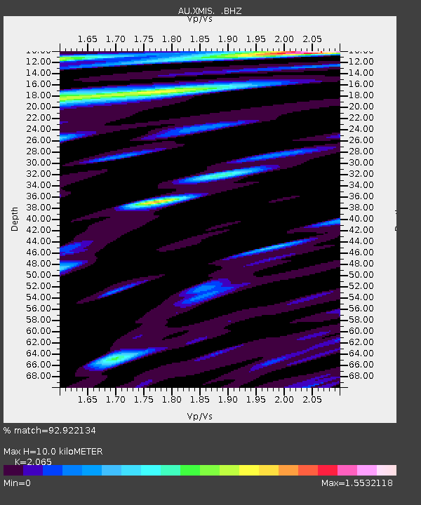
| Estimated Moho Depth: |
10.0 km |
| Estimated Crust Vp/Vs: |
2.07 |
| Assumed Crust Vp: |
4.157 km/s |
| Estimated Crust Vs: |
2.013 km/s |
| Estimated Crust Poisson's Ratio: |
0.35 |
|
| Radial Match: |
92.922134 % |
| Radial Bump: |
380 |
| Transverse Match: |
74.72777 % |
| Transverse Bump: |
400 |
| SOD ConfigId: |
2622 |
| Insert Time: |
2010-03-09 00:34:44.218 +0000 |
| GWidth: |
2.5 |
| Max Bumps: |
400 |
| Tol: |
0.001 |
|

Signal To Noise
| Channel | StoN | STA | LTA |
| AU:XMIS: :BHZ:20090809T11:04:13.16899Z | 23.913414 | 1.0671781E-5 | 4.4626756E-7 |
| AU:XMIS: :BHN:20090809T11:04:13.16899Z | 7.8127666 | 4.1663243E-6 | 5.3327136E-7 |
| AU:XMIS: :BHE:20090809T11:04:13.16899Z | 6.876254 | 3.8892395E-6 | 5.6560435E-7 |
| Arrivals |
| Ps | 2.6 SECOND |
| PpPs | 7.2 SECOND |
| PsPs/PpSs | 9.9 SECOND |


