You are here: Home > Network List > AU - Australian Seismological Centre Stations List
> Station XMIS Christmas Island, Australia > Earthquake Result Viewer
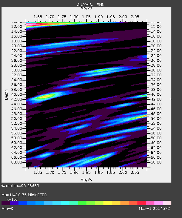
XMIS Christmas Island, Australia - Earthquake Result Viewer
| Earthquake location: |
Fiji Islands Region |
| Earthquake latitude/longitude: |
-19.9/-178.2 |
| Earthquake time(UTC): |
2006/01/02 (002) 22:13:40 GMT |
| Earthquake Depth: |
583 km |
| Earthquake Magnitude: |
6.5 MB, 7.2 MW, 7.1 MW |
| Earthquake Catalog/Contributor: |
WHDF/NEIC |
|
| Network: |
AU Australian Seismological Centre |
| Station: |
XMIS Christmas Island, Australia |
| Lat/Lon: |
10.48 S/105.65 E |
| Elevation: |
245 m |
|
| Distance: |
73.6 deg |
| Az: |
264.593 deg |
| Baz: |
107.757 deg |
| Ray Param: |
0.05096995 |
| Estimated Moho Depth: |
10.75 km |
| Estimated Crust Vp/Vs: |
1.60 |
| Assumed Crust Vp: |
4.157 km/s |
| Estimated Crust Vs: |
2.598 km/s |
| Estimated Crust Poisson's Ratio: |
0.18 |
|
| Radial Match: |
93.26653 % |
| Radial Bump: |
388 |
| Transverse Match: |
81.89584 % |
| Transverse Bump: |
400 |
| SOD ConfigId: |
5423 |
| Insert Time: |
2010-03-09 00:35:06.361 +0000 |
| GWidth: |
2.5 |
| Max Bumps: |
400 |
| Tol: |
0.001 |
|

Signal To Noise
| Channel | StoN | STA | LTA |
| AU:XMIS: :BHN:20060102T22:23:44.169016Z | 2.1690705 | 2.2334441E-12 | 1.0296779E-12 |
| AU:XMIS: :BHE:20060102T22:23:44.169016Z | 4.1667953 | 3.8116147E-12 | 9.147593E-13 |
| AU:XMIS: :BHZ:20060102T22:23:44.169016Z | 12.69577 | 1.0541709E-11 | 8.3033233E-13 |
| Arrivals |
| Ps | 1.6 SECOND |
| PpPs | 6.6 SECOND |
| PsPs/PpSs | 8.2 SECOND |


