You are here: Home > Network List > AU - Australian Seismological Centre Stations List
> Station XMIS Christmas Island, Australia > Earthquake Result Viewer
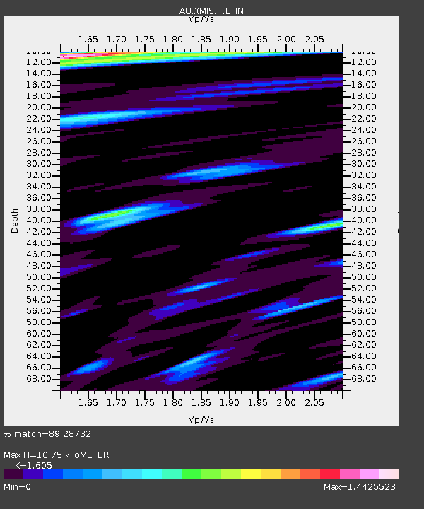
XMIS Christmas Island, Australia - Earthquake Result Viewer
| Earthquake location: |
Vanuatu Islands |
| Earthquake latitude/longitude: |
-15.8/167.8 |
| Earthquake time(UTC): |
2006/08/07 (219) 22:18:54 GMT |
| Earthquake Depth: |
141 km |
| Earthquake Magnitude: |
6.0 MB, 6.8 MW, 6.8 MW |
| Earthquake Catalog/Contributor: |
WHDF/NEIC |
|
| Network: |
AU Australian Seismological Centre |
| Station: |
XMIS Christmas Island, Australia |
| Lat/Lon: |
10.48 S/105.65 E |
| Elevation: |
245 m |
|
| Distance: |
60.6 deg |
| Az: |
266.719 deg |
| Baz: |
102.226 deg |
| Ray Param: |
0.061013196 |
| Estimated Moho Depth: |
10.75 km |
| Estimated Crust Vp/Vs: |
1.61 |
| Assumed Crust Vp: |
4.157 km/s |
| Estimated Crust Vs: |
2.59 km/s |
| Estimated Crust Poisson's Ratio: |
0.18 |
|
| Radial Match: |
89.28732 % |
| Radial Bump: |
400 |
| Transverse Match: |
72.13031 % |
| Transverse Bump: |
400 |
| SOD ConfigId: |
2665 |
| Insert Time: |
2010-03-09 00:35:10.743 +0000 |
| GWidth: |
2.5 |
| Max Bumps: |
400 |
| Tol: |
0.001 |
|

Signal To Noise
| Channel | StoN | STA | LTA |
| AU:XMIS: :BHN:20060807T22:28:19.020Z | 2.942509 | 4.6146607E-12 | 1.5682742E-12 |
| AU:XMIS: :BHE:20060807T22:28:19.020Z | 5.5632424 | 1.0081029E-11 | 1.812078E-12 |
| AU:XMIS: :BHZ:20060807T22:28:19.020Z | 16.842922 | 1.9972907E-11 | 1.1858338E-12 |
| Arrivals |
| Ps | 1.6 SECOND |
| PpPs | 6.6 SECOND |
| PsPs/PpSs | 8.2 SECOND |


