You are here: Home > Network List > AU - Australian Seismological Centre Stations List
> Station XMIS Christmas Island, Australia > Earthquake Result Viewer
XMIS Christmas Island, Australia - Earthquake Result Viewer
| Earthquake location: |
South Of Mariana Islands |
| Earthquake latitude/longitude: |
10.5/145.7 |
| Earthquake time(UTC): |
2007/09/30 (273) 02:08:30 GMT |
| Earthquake Depth: |
14 km |
| Earthquake Magnitude: |
6.4 MB, 7.1 MS, 6.9 MW, 6.9 MW |
| Earthquake Catalog/Contributor: |
WHDF/NEIC |
|
| Network: |
AU Australian Seismological Centre |
| Station: |
XMIS Christmas Island, Australia |
| Lat/Lon: |
10.48 S/105.65 E |
| Elevation: |
245 m |
|
| Distance: |
44.9 deg |
| Az: |
243.658 deg |
| Baz: |
63.668 deg |
| Ray Param: |
0.07159285 |
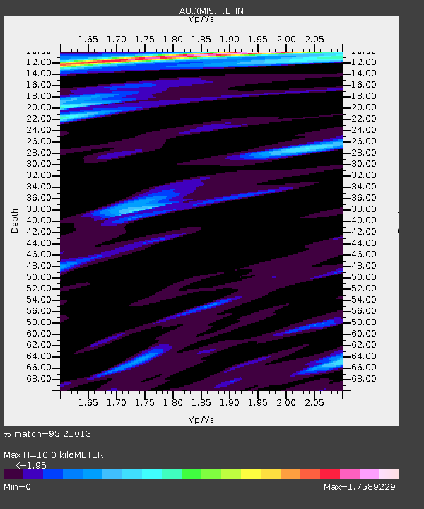
| Estimated Moho Depth: |
10.0 km |
| Estimated Crust Vp/Vs: |
1.95 |
| Assumed Crust Vp: |
4.157 km/s |
| Estimated Crust Vs: |
2.132 km/s |
| Estimated Crust Poisson's Ratio: |
0.32 |
|
| Radial Match: |
95.21013 % |
| Radial Bump: |
297 |
| Transverse Match: |
85.41226 % |
| Transverse Bump: |
400 |
| SOD ConfigId: |
2564 |
| Insert Time: |
2010-03-09 00:35:26.421 +0000 |
| GWidth: |
2.5 |
| Max Bumps: |
400 |
| Tol: |
0.001 |
|

Signal To Noise
| Channel | StoN | STA | LTA |
| AU:XMIS: :BHN:20070930T02:16:13.670Z | 0.7893707 | 6.8471417E-13 | 8.6741774E-13 |
| AU:XMIS: :BHE:20070930T02:16:13.670Z | 3.2206237 | 2.3379749E-12 | 7.259385E-13 |
| AU:XMIS: :BHZ:20070930T02:16:13.670Z | 6.3577743 | 4.289585E-12 | 6.7469923E-13 |
| Arrivals |
| Ps | 2.3 SECOND |
| PpPs | 6.9 SECOND |
| PsPs/PpSs | 9.3 SECOND |


