You are here: Home > Network List > TA - USArray Transportable Network (new EarthScope stations) Stations List
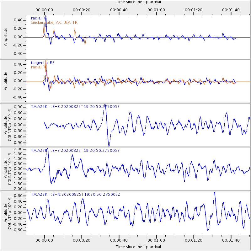
> Station A22K Sinclair Lake, AK, USA > Earthquake Result Viewer
A22K Sinclair Lake, AK, USA - Earthquake Result Viewer
| Earthquake location: |
New Britain Region, P.N.G. |
| Earthquake latitude/longitude: |
-5.5/151.8 |
| Earthquake time(UTC): |
2020/08/25 (238) 19:08:53 GMT |
| Earthquake Depth: |
24 km |
| Earthquake Magnitude: |
6.1 mww |
| Earthquake Catalog/Contributor: |
NEIC PDE/us |
|
| Network: |
TA USArray Transportable Network (new EarthScope stations) |
| Station: |
A22K Sinclair Lake, AK, USA |
| Lat/Lon: |
71.00 N/154.97 W |
| Elevation: |
6.0 m |
|
| Distance: |
83.9 deg |
| Az: |
15.287 deg |
| Baz: |
233.269 deg |
| Ray Param: |
0.045801133 |
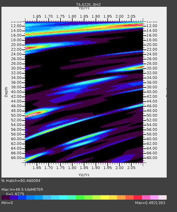
| Estimated Moho Depth: |
49.5 km |
| Estimated Crust Vp/Vs: |
1.63 |
| Assumed Crust Vp: |
5.782 km/s |
| Estimated Crust Vs: |
3.553 km/s |
| Estimated Crust Poisson's Ratio: |
0.20 |
|
| Radial Match: |
90.468094 % |
| Radial Bump: |
242 |
| Transverse Match: |
77.448944 % |
| Transverse Bump: |
367 |
| SOD ConfigId: |
21709731 |
| Insert Time: |
2020-09-08 19:48:45.583 +0000 |
| GWidth: |
2.5 |
| Max Bumps: |
400 |
| Tol: |
0.001 |
|
Signal To Noise
| Channel | StoN | STA | LTA |
| TA:A22K: :BHZ:20200825T19:20:50.275005Z | 11.329613 | 1.1744586E-6 | 1.03662735E-7 |
| TA:A22K: :BHN:20200825T19:20:50.275005Z | 2.0935192 | 2.2671337E-7 | 1.08292944E-7 |
| TA:A22K: :BHE:20200825T19:20:50.275005Z | 6.959725 | 6.132823E-7 | 8.811875E-8 |
| Arrivals |
| Ps | 5.5 SECOND |
| PpPs | 22 SECOND |
| PsPs/PpSs | 27 SECOND |


