You are here: Home > Network List > TA - USArray Transportable Network (new EarthScope stations) Stations List
> Station B18K Kokolik River, AK, USA > Earthquake Result Viewer
B18K Kokolik River, AK, USA - Earthquake Result Viewer
| Earthquake location: |
New Britain Region, P.N.G. |
| Earthquake latitude/longitude: |
-5.5/151.8 |
| Earthquake time(UTC): |
2020/08/25 (238) 19:08:53 GMT |
| Earthquake Depth: |
24 km |
| Earthquake Magnitude: |
6.1 mww |
| Earthquake Catalog/Contributor: |
NEIC PDE/us |
|
| Network: |
TA USArray Transportable Network (new EarthScope stations) |
| Station: |
B18K Kokolik River, AK, USA |
| Lat/Lon: |
69.36 N/161.80 W |
| Elevation: |
222 m |
|
| Distance: |
81.1 deg |
| Az: |
15.051 deg |
| Baz: |
226.819 deg |
| Ray Param: |
0.047799315 |
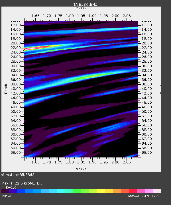
| Estimated Moho Depth: |
22.5 km |
| Estimated Crust Vp/Vs: |
1.60 |
| Assumed Crust Vp: |
5.906 km/s |
| Estimated Crust Vs: |
3.692 km/s |
| Estimated Crust Poisson's Ratio: |
0.18 |
|
| Radial Match: |
85.3563 % |
| Radial Bump: |
400 |
| Transverse Match: |
74.63344 % |
| Transverse Bump: |
400 |
| SOD ConfigId: |
21709731 |
| Insert Time: |
2020-09-08 19:48:48.582 +0000 |
| GWidth: |
2.5 |
| Max Bumps: |
400 |
| Tol: |
0.001 |
|
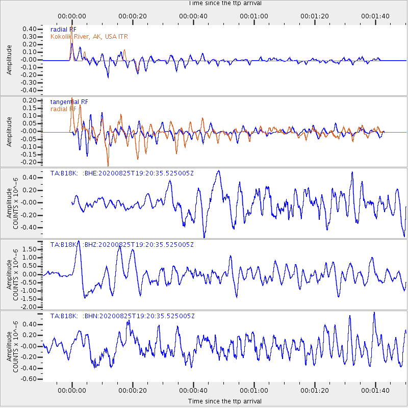
Signal To Noise
| Channel | StoN | STA | LTA |
| TA:B18K: :BHZ:20200825T19:20:35.525005Z | 7.308293 | 1.1246592E-6 | 1.538881E-7 |
| TA:B18K: :BHN:20200825T19:20:35.525005Z | 2.6085203 | 1.7477443E-7 | 6.7001366E-8 |
| TA:B18K: :BHE:20200825T19:20:35.525005Z | 2.9026268 | 1.8085964E-7 | 6.2308956E-8 |
| Arrivals |
| Ps | 2.3 SECOND |
| PpPs | 9.7 SECOND |
| PsPs/PpSs | 12 SECOND |


