You are here: Home > Network List > TA - USArray Transportable Network (new EarthScope stations) Stations List
> Station D17K Noatak River, AK, USA > Earthquake Result Viewer
D17K Noatak River, AK, USA - Earthquake Result Viewer
| Earthquake location: |
New Britain Region, P.N.G. |
| Earthquake latitude/longitude: |
-5.5/151.8 |
| Earthquake time(UTC): |
2020/08/25 (238) 19:08:53 GMT |
| Earthquake Depth: |
24 km |
| Earthquake Magnitude: |
6.1 mww |
| Earthquake Catalog/Contributor: |
NEIC PDE/us |
|
| Network: |
TA USArray Transportable Network (new EarthScope stations) |
| Station: |
D17K Noatak River, AK, USA |
| Lat/Lon: |
67.70 N/163.08 W |
| Elevation: |
172 m |
|
| Distance: |
79.6 deg |
| Az: |
15.948 deg |
| Baz: |
225.777 deg |
| Ray Param: |
0.048820328 |
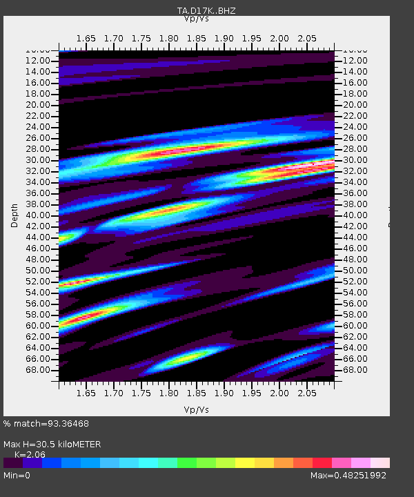
| Estimated Moho Depth: |
30.5 km |
| Estimated Crust Vp/Vs: |
2.06 |
| Assumed Crust Vp: |
6.276 km/s |
| Estimated Crust Vs: |
3.047 km/s |
| Estimated Crust Poisson's Ratio: |
0.35 |
|
| Radial Match: |
93.36468 % |
| Radial Bump: |
331 |
| Transverse Match: |
87.20929 % |
| Transverse Bump: |
354 |
| SOD ConfigId: |
21709731 |
| Insert Time: |
2020-09-08 19:49:04.900 +0000 |
| GWidth: |
2.5 |
| Max Bumps: |
400 |
| Tol: |
0.001 |
|

Signal To Noise
| Channel | StoN | STA | LTA |
| TA:D17K: :BHZ:20200825T19:20:27.525005Z | 10.357251 | 8.9446144E-7 | 8.636089E-8 |
| TA:D17K: :BHN:20200825T19:20:27.525005Z | 7.2462816 | 3.412372E-7 | 4.7091355E-8 |
| TA:D17K: :BHE:20200825T19:20:27.525005Z | 4.9756193 | 2.5983297E-7 | 5.2221232E-8 |
| Arrivals |
| Ps | 5.3 SECOND |
| PpPs | 15 SECOND |
| PsPs/PpSs | 20 SECOND |


