You are here: Home > Network List > TA - USArray Transportable Network (new EarthScope stations) Stations List
> Station F14K Arctic Creek, AK, USA > Earthquake Result Viewer
F14K Arctic Creek, AK, USA - Earthquake Result Viewer

| Earthquake location: |
New Britain Region, P.N.G. |
| Earthquake latitude/longitude: |
-5.5/151.8 |
| Earthquake time(UTC): |
2020/08/25 (238) 19:08:53 GMT |
| Earthquake Depth: |
24 km |
| Earthquake Magnitude: |
6.1 mww |
| Earthquake Catalog/Contributor: |
NEIC PDE/us |
|
| Network: |
TA USArray Transportable Network (new EarthScope stations) |
| Station: |
F14K Arctic Creek, AK, USA |
| Lat/Lon: |
65.47 N/166.33 W |
| Elevation: |
266 m |
|
| Distance: |
77.1 deg |
| Az: |
16.595 deg |
| Baz: |
222.932 deg |
| Ray Param: |
0.050521843 |
| Estimated Moho Depth: |
34.5 km |
| Estimated Crust Vp/Vs: |
1.60 |
| Assumed Crust Vp: |
6.307 km/s |
| Estimated Crust Vs: |
3.942 km/s |
| Estimated Crust Poisson's Ratio: |
0.18 |
|
| Radial Match: |
93.19772 % |
| Radial Bump: |
379 |
| Transverse Match: |
79.82637 % |
| Transverse Bump: |
400 |
| SOD ConfigId: |
21709731 |
| Insert Time: |
2020-09-08 19:49:35.478 +0000 |
| GWidth: |
2.5 |
| Max Bumps: |
400 |
| Tol: |
0.001 |
|
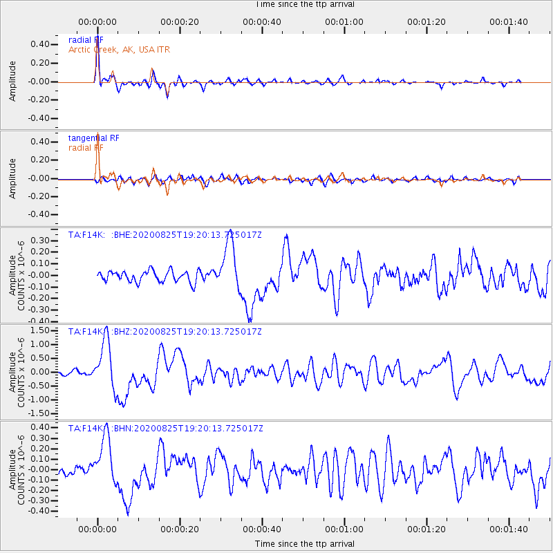
Signal To Noise
| Channel | StoN | STA | LTA |
| TA:F14K: :BHZ:20200825T19:20:13.725017Z | 12.95619 | 9.0554505E-7 | 6.989285E-8 |
| TA:F14K: :BHN:20200825T19:20:13.725017Z | 5.256695 | 2.3880838E-7 | 4.5429378E-8 |
| TA:F14K: :BHE:20200825T19:20:13.725017Z | 4.5799575 | 2.1847517E-7 | 4.7702443E-8 |
| Arrivals |
| Ps | 3.4 SECOND |
| PpPs | 14 SECOND |
| PsPs/PpSs | 17 SECOND |


