You are here: Home > Network List > TA - USArray Transportable Network (new EarthScope stations) Stations List
> Station G15K Niukluk, AK, USA > Earthquake Result Viewer
G15K Niukluk, AK, USA - Earthquake Result Viewer
| Earthquake location: |
New Britain Region, P.N.G. |
| Earthquake latitude/longitude: |
-5.5/151.8 |
| Earthquake time(UTC): |
2020/08/25 (238) 19:08:53 GMT |
| Earthquake Depth: |
24 km |
| Earthquake Magnitude: |
6.1 mww |
| Earthquake Catalog/Contributor: |
NEIC PDE/us |
|
| Network: |
TA USArray Transportable Network (new EarthScope stations) |
| Station: |
G15K Niukluk, AK, USA |
| Lat/Lon: |
64.99 N/164.04 W |
| Elevation: |
249 m |
|
| Distance: |
77.4 deg |
| Az: |
17.649 deg |
| Baz: |
225.242 deg |
| Ray Param: |
0.050307523 |
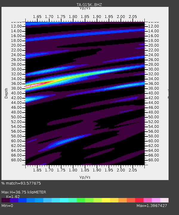
| Estimated Moho Depth: |
36.75 km |
| Estimated Crust Vp/Vs: |
1.62 |
| Assumed Crust Vp: |
6.276 km/s |
| Estimated Crust Vs: |
3.874 km/s |
| Estimated Crust Poisson's Ratio: |
0.19 |
|
| Radial Match: |
93.577675 % |
| Radial Bump: |
400 |
| Transverse Match: |
73.12571 % |
| Transverse Bump: |
400 |
| SOD ConfigId: |
21709731 |
| Insert Time: |
2020-09-08 19:49:54.515 +0000 |
| GWidth: |
2.5 |
| Max Bumps: |
400 |
| Tol: |
0.001 |
|

Signal To Noise
| Channel | StoN | STA | LTA |
| TA:G15K: :BHZ:20200825T19:20:15.550029Z | 13.776586 | 1.0384639E-6 | 7.53789E-8 |
| TA:G15K: :BHN:20200825T19:20:15.550029Z | 5.2256737 | 2.5126977E-7 | 4.8083706E-8 |
| TA:G15K: :BHE:20200825T19:20:15.550029Z | 6.0350275 | 2.4464E-7 | 4.0536683E-8 |
| Arrivals |
| Ps | 3.7 SECOND |
| PpPs | 15 SECOND |
| PsPs/PpSs | 19 SECOND |


