You are here: Home > Network List > TA - USArray Transportable Network (new EarthScope stations) Stations List
> Station J30M Hart River, Yukon, CAN > Earthquake Result Viewer
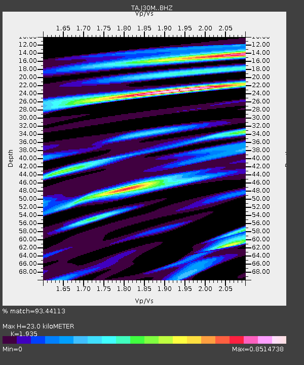
J30M Hart River, Yukon, CAN - Earthquake Result Viewer
| Earthquake location: |
New Britain Region, P.N.G. |
| Earthquake latitude/longitude: |
-5.5/151.8 |
| Earthquake time(UTC): |
2020/08/25 (238) 19:08:53 GMT |
| Earthquake Depth: |
24 km |
| Earthquake Magnitude: |
6.1 mww |
| Earthquake Catalog/Contributor: |
NEIC PDE/us |
|
| Network: |
TA USArray Transportable Network (new EarthScope stations) |
| Station: |
J30M Hart River, Yukon, CAN |
| Lat/Lon: |
64.58 N/136.33 W |
| Elevation: |
1419 m |
|
| Distance: |
87.2 deg |
| Az: |
24.245 deg |
| Baz: |
251.252 deg |
| Ray Param: |
0.04344349 |
| Estimated Moho Depth: |
23.0 km |
| Estimated Crust Vp/Vs: |
1.93 |
| Assumed Crust Vp: |
6.566 km/s |
| Estimated Crust Vs: |
3.393 km/s |
| Estimated Crust Poisson's Ratio: |
0.32 |
|
| Radial Match: |
93.44113 % |
| Radial Bump: |
400 |
| Transverse Match: |
88.48232 % |
| Transverse Bump: |
400 |
| SOD ConfigId: |
21709731 |
| Insert Time: |
2020-09-08 19:50:35.427 +0000 |
| GWidth: |
2.5 |
| Max Bumps: |
400 |
| Tol: |
0.001 |
|

Signal To Noise
| Channel | StoN | STA | LTA |
| TA:J30M: :BHZ:20200825T19:21:06.574993Z | 12.070041 | 1.0259365E-6 | 8.499859E-8 |
| TA:J30M: :BHN:20200825T19:21:06.574993Z | 4.140348 | 2.0134897E-7 | 4.863093E-8 |
| TA:J30M: :BHE:20200825T19:21:06.574993Z | 9.688036 | 4.2344217E-7 | 4.3707743E-8 |
| Arrivals |
| Ps | 3.3 SECOND |
| PpPs | 10 SECOND |
| PsPs/PpSs | 13 SECOND |


