You are here: Home > Network List > US - United States National Seismic Network Stations List
> Station CBKS Cedar Bluff, Kansas, USA > Earthquake Result Viewer
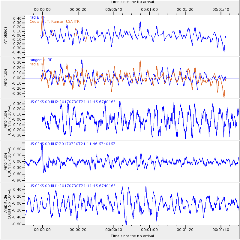
CBKS Cedar Bluff, Kansas, USA - Earthquake Result Viewer
*The percent match for this event was below the threshold and hence no stack was calculated.
| Earthquake location: |
Kuril Islands |
| Earthquake latitude/longitude: |
46.2/151.0 |
| Earthquake time(UTC): |
2017/07/30 (211) 21:00:49 GMT |
| Earthquake Depth: |
87 km |
| Earthquake Magnitude: |
5.7 mb |
| Earthquake Catalog/Contributor: |
NEIC PDE/us |
|
| Network: |
US United States National Seismic Network |
| Station: |
CBKS Cedar Bluff, Kansas, USA |
| Lat/Lon: |
38.81 N/99.74 W |
| Elevation: |
677 m |
|
| Distance: |
74.3 deg |
| Az: |
49.967 deg |
| Baz: |
317.109 deg |
| Ray Param: |
$rayparam |
*The percent match for this event was below the threshold and hence was not used in the summary stack. |
|
| Radial Match: |
51.191082 % |
| Radial Bump: |
400 |
| Transverse Match: |
54.31141 % |
| Transverse Bump: |
400 |
| SOD ConfigId: |
2140511 |
| Insert Time: |
2017-08-13 13:00:49.188 +0000 |
| GWidth: |
2.5 |
| Max Bumps: |
400 |
| Tol: |
0.001 |
|
Signal To Noise
| Channel | StoN | STA | LTA |
| US:CBKS:00:BHZ:20170730T21:11:46.674016Z | 2.8988888 | 3.8557567E-7 | 1.3300809E-7 |
| US:CBKS:00:BH1:20170730T21:11:46.674016Z | 1.3570253 | 1.6495912E-7 | 1.2155935E-7 |
| US:CBKS:00:BH2:20170730T21:11:46.674016Z | 0.77324027 | 1.10618544E-7 | 1.4305843E-7 |
| Arrivals |
| Ps | |
| PpPs | |
| PsPs/PpSs | |


