You are here: Home > Network List > US - United States National Seismic Network Stations List
> Station DUG Dugway, Tooele County, Utah, USA > Earthquake Result Viewer
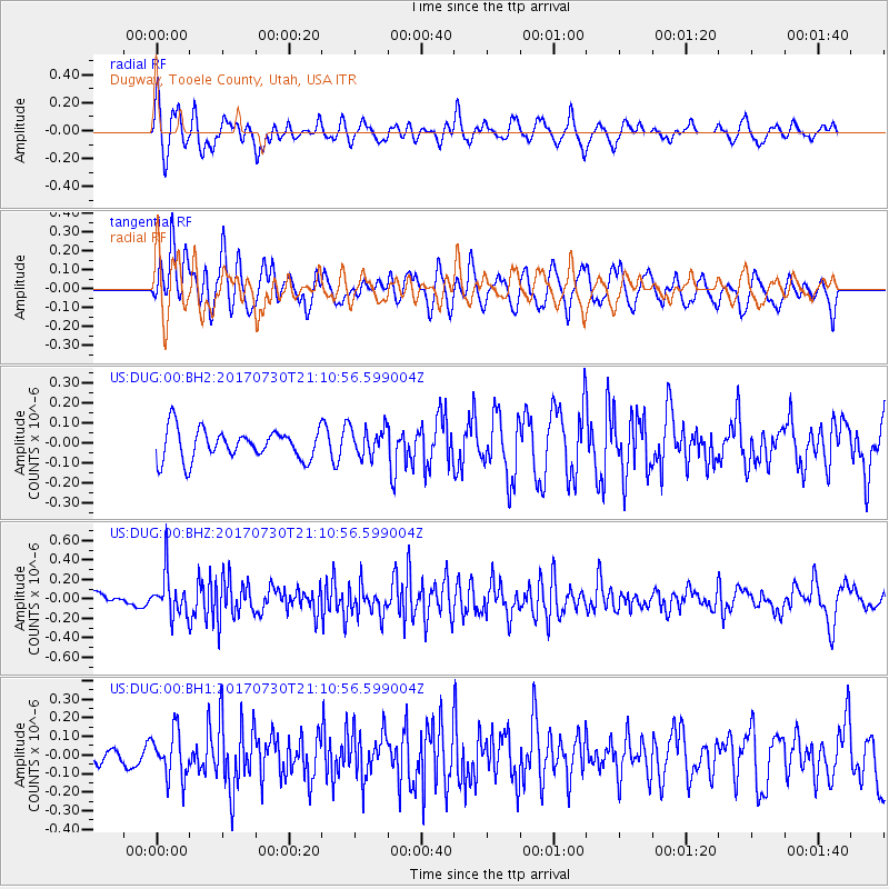
DUG Dugway, Tooele County, Utah, USA - Earthquake Result Viewer
*The percent match for this event was below the threshold and hence no stack was calculated.
| Earthquake location: |
Kuril Islands |
| Earthquake latitude/longitude: |
46.2/151.0 |
| Earthquake time(UTC): |
2017/07/30 (211) 21:00:49 GMT |
| Earthquake Depth: |
87 km |
| Earthquake Magnitude: |
5.7 mb |
| Earthquake Catalog/Contributor: |
NEIC PDE/us |
|
| Network: |
US United States National Seismic Network |
| Station: |
DUG Dugway, Tooele County, Utah, USA |
| Lat/Lon: |
40.19 N/112.81 W |
| Elevation: |
1477 m |
|
| Distance: |
66.1 deg |
| Az: |
56.381 deg |
| Baz: |
310.979 deg |
| Ray Param: |
$rayparam |
*The percent match for this event was below the threshold and hence was not used in the summary stack. |
|
| Radial Match: |
67.967606 % |
| Radial Bump: |
400 |
| Transverse Match: |
70.799904 % |
| Transverse Bump: |
400 |
| SOD ConfigId: |
2140511 |
| Insert Time: |
2017-08-13 13:00:57.570 +0000 |
| GWidth: |
2.5 |
| Max Bumps: |
400 |
| Tol: |
0.001 |
|
Signal To Noise
| Channel | StoN | STA | LTA |
| US:DUG:00:BHZ:20170730T21:10:56.599004Z | 2.1813538 | 2.1316858E-7 | 9.772307E-8 |
| US:DUG:00:BH1:20170730T21:10:56.599004Z | 2.5082376 | 1.2334831E-7 | 4.9177288E-8 |
| US:DUG:00:BH2:20170730T21:10:56.599004Z | 0.95511514 | 7.2384644E-8 | 7.57863E-8 |
| Arrivals |
| Ps | |
| PpPs | |
| PsPs/PpSs | |


