You are here: Home > Network List > IU - Global Seismograph Network (GSN - IRIS/USGS) Stations List
> Station PMG Port Moresby, New Guinea > Earthquake Result Viewer
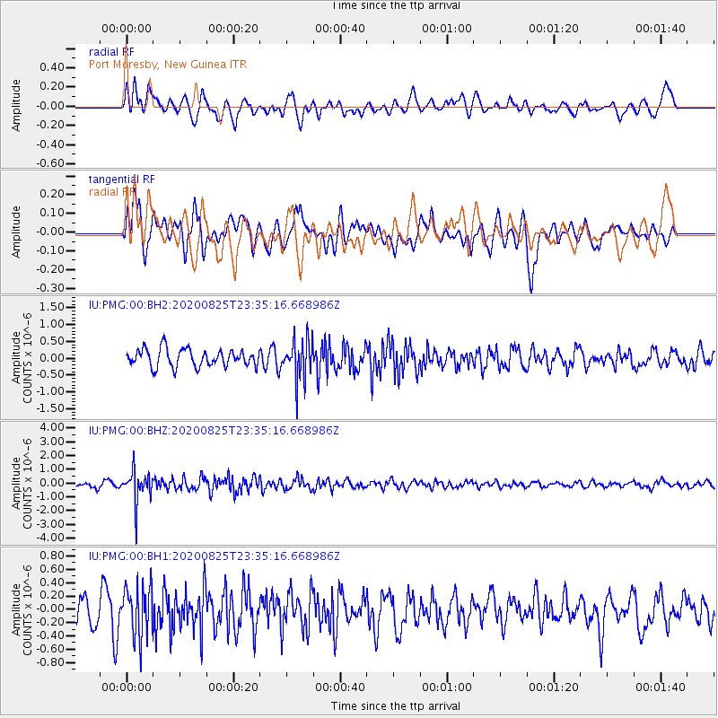
PMG Port Moresby, New Guinea - Earthquake Result Viewer
*The percent match for this event was below the threshold and hence no stack was calculated.
| Earthquake location: |
Sunda Strait, Indonesia |
| Earthquake latitude/longitude: |
-6.7/104.7 |
| Earthquake time(UTC): |
2020/08/25 (238) 23:27:57 GMT |
| Earthquake Depth: |
35 km |
| Earthquake Magnitude: |
5.1 Mww |
| Earthquake Catalog/Contributor: |
NEIC PDE/us |
|
| Network: |
IU Global Seismograph Network (GSN - IRIS/USGS) |
| Station: |
PMG Port Moresby, New Guinea |
| Lat/Lon: |
9.40 S/147.16 E |
| Elevation: |
90 m |
|
| Distance: |
42.2 deg |
| Az: |
96.63 deg |
| Baz: |
270.449 deg |
| Ray Param: |
$rayparam |
*The percent match for this event was below the threshold and hence was not used in the summary stack. |
|
| Radial Match: |
50.38435 % |
| Radial Bump: |
400 |
| Transverse Match: |
53.39078 % |
| Transverse Bump: |
400 |
| SOD ConfigId: |
21709731 |
| Insert Time: |
2020-09-08 23:31:09.079 +0000 |
| GWidth: |
2.5 |
| Max Bumps: |
400 |
| Tol: |
0.001 |
|
Signal To Noise
| Channel | StoN | STA | LTA |
| IU:PMG:00:BHZ:20200825T23:35:16.668986Z | 5.9646673 | 1.0884302E-6 | 1.8247961E-7 |
| IU:PMG:00:BH1:20200825T23:35:16.668986Z | 1.8385444 | 3.7266915E-7 | 2.0269795E-7 |
| IU:PMG:00:BH2:20200825T23:35:16.668986Z | 2.2809997 | 5.939045E-7 | 2.6037026E-7 |
| Arrivals |
| Ps | |
| PpPs | |
| PsPs/PpSs | |


