You are here: Home > Network List > US - United States National Seismic Network Stations List
> Station MIAR Mount Ida, Arkansas, USA > Earthquake Result Viewer
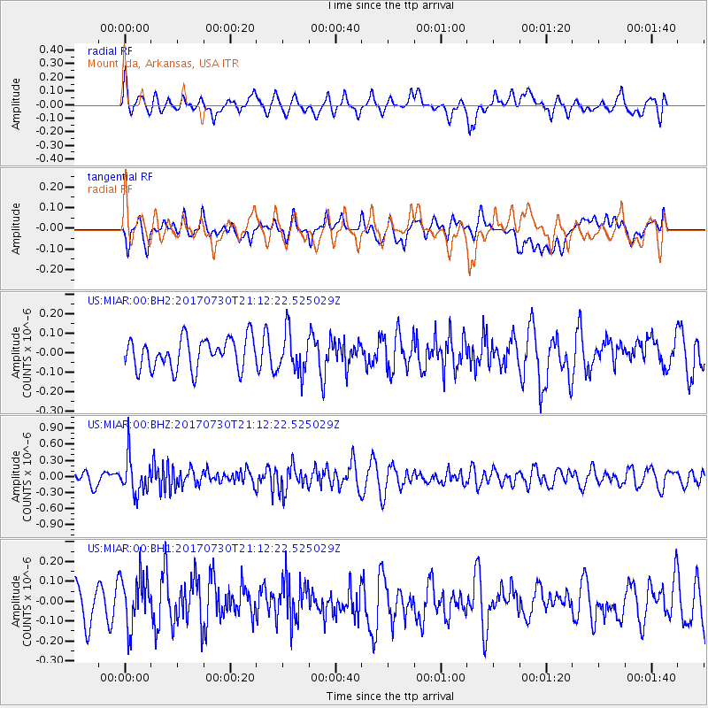
MIAR Mount Ida, Arkansas, USA - Earthquake Result Viewer
*The percent match for this event was below the threshold and hence no stack was calculated.
| Earthquake location: |
Kuril Islands |
| Earthquake latitude/longitude: |
46.2/151.0 |
| Earthquake time(UTC): |
2017/07/30 (211) 21:00:49 GMT |
| Earthquake Depth: |
87 km |
| Earthquake Magnitude: |
5.7 mb |
| Earthquake Catalog/Contributor: |
NEIC PDE/us |
|
| Network: |
US United States National Seismic Network |
| Station: |
MIAR Mount Ida, Arkansas, USA |
| Lat/Lon: |
34.55 N/93.58 W |
| Elevation: |
207 m |
|
| Distance: |
80.8 deg |
| Az: |
49.017 deg |
| Baz: |
320.574 deg |
| Ray Param: |
$rayparam |
*The percent match for this event was below the threshold and hence was not used in the summary stack. |
|
| Radial Match: |
63.568386 % |
| Radial Bump: |
400 |
| Transverse Match: |
56.040203 % |
| Transverse Bump: |
400 |
| SOD ConfigId: |
2140511 |
| Insert Time: |
2017-08-13 13:02:13.581 +0000 |
| GWidth: |
2.5 |
| Max Bumps: |
400 |
| Tol: |
0.001 |
|
Signal To Noise
| Channel | StoN | STA | LTA |
| US:MIAR:00:BHZ:20170730T21:12:22.525029Z | 2.8491547 | 3.368973E-7 | 1.1824464E-7 |
| US:MIAR:00:BH1:20170730T21:12:22.525029Z | 1.4643984 | 1.3017022E-7 | 8.88899E-8 |
| US:MIAR:00:BH2:20170730T21:12:22.525029Z | 1.2868553 | 1.0243791E-7 | 7.960328E-8 |
| Arrivals |
| Ps | |
| PpPs | |
| PsPs/PpSs | |


