You are here: Home > Network List > GS - US Geological Survey Networks Stations List
> Station PR01 PR01, Lajas > Earthquake Result Viewer
PR01 PR01, Lajas - Earthquake Result Viewer
| Earthquake location: |
Central Mid-Atlantic Ridge |
| Earthquake latitude/longitude: |
0.9/-29.7 |
| Earthquake time(UTC): |
2020/08/30 (243) 21:20:28 GMT |
| Earthquake Depth: |
10 km |
| Earthquake Magnitude: |
6.5 mww |
| Earthquake Catalog/Contributor: |
NEIC PDE/us |
|
| Network: |
GS US Geological Survey Networks |
| Station: |
PR01 PR01, Lajas |
| Lat/Lon: |
18.03 N/67.07 W |
| Elevation: |
33 m |
|
| Distance: |
40.5 deg |
| Az: |
297.163 deg |
| Baz: |
110.776 deg |
| Ray Param: |
0.07438692 |
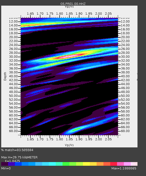
| Estimated Moho Depth: |
29.75 km |
| Estimated Crust Vp/Vs: |
1.84 |
| Assumed Crust Vp: |
5.14 km/s |
| Estimated Crust Vs: |
2.79 km/s |
| Estimated Crust Poisson's Ratio: |
0.29 |
|
| Radial Match: |
83.585594 % |
| Radial Bump: |
350 |
| Transverse Match: |
61.113007 % |
| Transverse Bump: |
400 |
| SOD ConfigId: |
21709731 |
| Insert Time: |
2020-09-13 21:30:39.960 +0000 |
| GWidth: |
2.5 |
| Max Bumps: |
400 |
| Tol: |
0.001 |
|

Signal To Noise
| Channel | StoN | STA | LTA |
| GS:PR01:00:HHZ:20200830T21:27:36.440005Z | 8.63873 | 1.4821179E-6 | 1.7156664E-7 |
| GS:PR01:00:HH1:20200830T21:27:36.440005Z | 2.0235116 | 4.4113364E-7 | 2.1800399E-7 |
| GS:PR01:00:HH2:20200830T21:27:36.440005Z | 4.435495 | 7.367413E-7 | 1.6610126E-7 |
| Arrivals |
| Ps | 5.1 SECOND |
| PpPs | 16 SECOND |
| PsPs/PpSs | 21 SECOND |


