You are here: Home > Network List > US - United States National Seismic Network Stations List
> Station WUAZ Wupatki, Arizona, USA > Earthquake Result Viewer
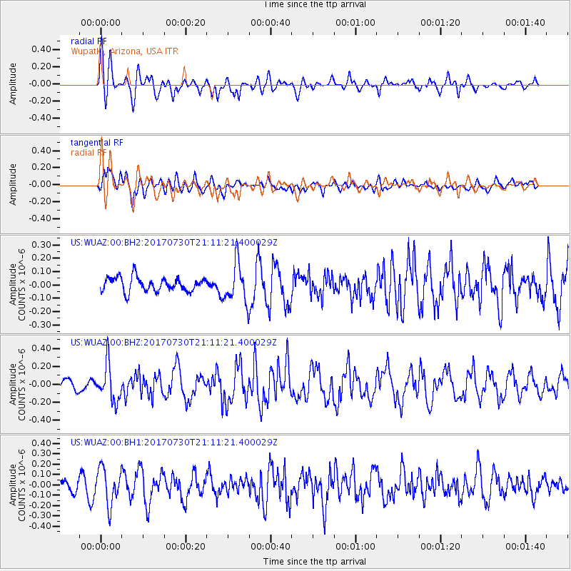
WUAZ Wupatki, Arizona, USA - Earthquake Result Viewer
*The percent match for this event was below the threshold and hence no stack was calculated.
| Earthquake location: |
Kuril Islands |
| Earthquake latitude/longitude: |
46.2/151.0 |
| Earthquake time(UTC): |
2017/07/30 (211) 21:00:49 GMT |
| Earthquake Depth: |
87 km |
| Earthquake Magnitude: |
5.7 mb |
| Earthquake Catalog/Contributor: |
NEIC PDE/us |
|
| Network: |
US United States National Seismic Network |
| Station: |
WUAZ Wupatki, Arizona, USA |
| Lat/Lon: |
35.52 N/111.37 W |
| Elevation: |
1592 m |
|
| Distance: |
70.1 deg |
| Az: |
59.302 deg |
| Baz: |
312.949 deg |
| Ray Param: |
$rayparam |
*The percent match for this event was below the threshold and hence was not used in the summary stack. |
|
| Radial Match: |
53.049255 % |
| Radial Bump: |
400 |
| Transverse Match: |
58.186085 % |
| Transverse Bump: |
400 |
| SOD ConfigId: |
2140511 |
| Insert Time: |
2017-08-13 13:02:47.025 +0000 |
| GWidth: |
2.5 |
| Max Bumps: |
400 |
| Tol: |
0.001 |
|
Signal To Noise
| Channel | StoN | STA | LTA |
| US:WUAZ:00:BHZ:20170730T21:11:21.400029Z | 3.8108885 | 2.0821778E-7 | 5.4637596E-8 |
| US:WUAZ:00:BH1:20170730T21:11:21.400029Z | 3.2699895 | 1.7866549E-7 | 5.463794E-8 |
| US:WUAZ:00:BH2:20170730T21:11:21.400029Z | 2.8814955 | 1.5154166E-7 | 5.2591325E-8 |
| Arrivals |
| Ps | |
| PpPs | |
| PsPs/PpSs | |


