You are here: Home > Network List > N4 - Central and EAstern US Network Stations List
> Station KSCO Kaye's Shedlock's, Cheyenne Wells, CO, USA > Earthquake Result Viewer
KSCO Kaye's Shedlock's, Cheyenne Wells, CO, USA - Earthquake Result Viewer
| Earthquake location: |
Central Mid-Atlantic Ridge |
| Earthquake latitude/longitude: |
0.9/-29.7 |
| Earthquake time(UTC): |
2020/08/30 (243) 21:20:28 GMT |
| Earthquake Depth: |
10 km |
| Earthquake Magnitude: |
6.5 mww |
| Earthquake Catalog/Contributor: |
NEIC PDE/us |
|
| Network: |
N4 Central and EAstern US Network |
| Station: |
KSCO Kaye's Shedlock's, Cheyenne Wells, CO, USA |
| Lat/Lon: |
39.01 N/102.63 W |
| Elevation: |
1382 m |
|
| Distance: |
76.2 deg |
| Az: |
309.932 deg |
| Baz: |
100.221 deg |
| Ray Param: |
0.051145457 |
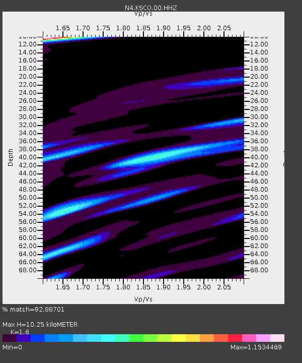
| Estimated Moho Depth: |
10.25 km |
| Estimated Crust Vp/Vs: |
1.60 |
| Assumed Crust Vp: |
6.242 km/s |
| Estimated Crust Vs: |
3.901 km/s |
| Estimated Crust Poisson's Ratio: |
0.18 |
|
| Radial Match: |
92.88701 % |
| Radial Bump: |
354 |
| Transverse Match: |
74.696754 % |
| Transverse Bump: |
400 |
| SOD ConfigId: |
21709731 |
| Insert Time: |
2020-09-13 21:33:41.217 +0000 |
| GWidth: |
2.5 |
| Max Bumps: |
400 |
| Tol: |
0.001 |
|

Signal To Noise
| Channel | StoN | STA | LTA |
| N4:KSCO:00:HHZ:20200830T21:31:45.740023Z | 5.552012 | 6.7271253E-7 | 1.2116554E-7 |
| N4:KSCO:00:HH1:20200830T21:31:45.740023Z | 0.90329427 | 1.672273E-7 | 1.8513047E-7 |
| N4:KSCO:00:HH2:20200830T21:31:45.740023Z | 1.3077512 | 2.105827E-7 | 1.6102658E-7 |
| Arrivals |
| Ps | 1.0 SECOND |
| PpPs | 4.1 SECOND |
| PsPs/PpSs | 5.1 SECOND |


