You are here: Home > Network List > N4 - Central and EAstern US Network Stations List
> Station O48B Farmland, IN, USA > Earthquake Result Viewer
O48B Farmland, IN, USA - Earthquake Result Viewer
| Earthquake location: |
Central Mid-Atlantic Ridge |
| Earthquake latitude/longitude: |
0.9/-29.7 |
| Earthquake time(UTC): |
2020/08/30 (243) 21:20:28 GMT |
| Earthquake Depth: |
10 km |
| Earthquake Magnitude: |
6.5 mww |
| Earthquake Catalog/Contributor: |
NEIC PDE/us |
|
| Network: |
N4 Central and EAstern US Network |
| Station: |
O48B Farmland, IN, USA |
| Lat/Lon: |
40.26 N/85.16 W |
| Elevation: |
300 m |
|
| Distance: |
63.7 deg |
| Az: |
315.305 deg |
| Baz: |
113.229 deg |
| Ray Param: |
0.059432674 |
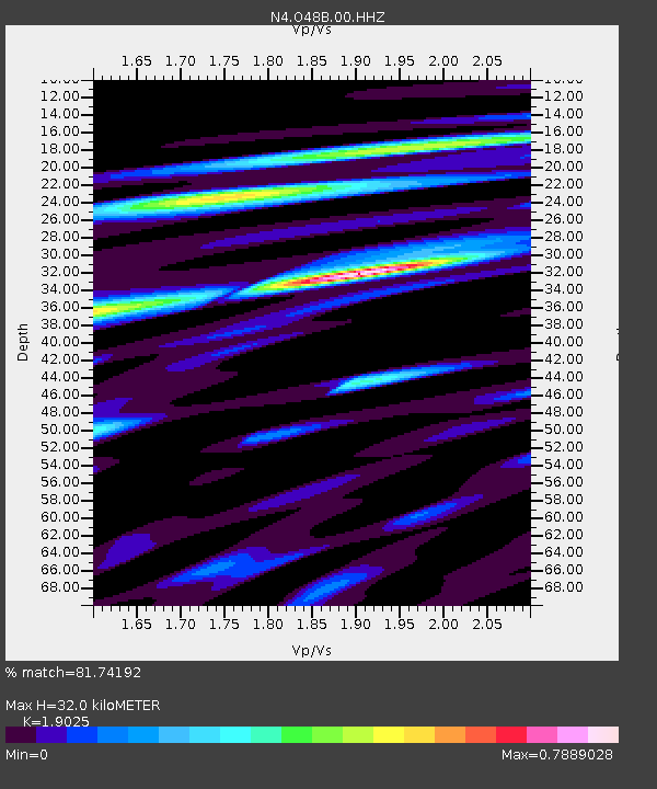
| Estimated Moho Depth: |
32.0 km |
| Estimated Crust Vp/Vs: |
1.90 |
| Assumed Crust Vp: |
6.498 km/s |
| Estimated Crust Vs: |
3.415 km/s |
| Estimated Crust Poisson's Ratio: |
0.31 |
|
| Radial Match: |
81.74192 % |
| Radial Bump: |
357 |
| Transverse Match: |
62.17467 % |
| Transverse Bump: |
400 |
| SOD ConfigId: |
21709731 |
| Insert Time: |
2020-09-13 21:34:03.857 +0000 |
| GWidth: |
2.5 |
| Max Bumps: |
400 |
| Tol: |
0.001 |
|

Signal To Noise
| Channel | StoN | STA | LTA |
| N4:O48B:00:HHZ:20200830T21:30:28.779024Z | 3.6820202 | 5.898414E-7 | 1.6019506E-7 |
| N4:O48B:00:HH1:20200830T21:30:28.779024Z | 1.4358873 | 1.940298E-7 | 1.3512886E-7 |
| N4:O48B:00:HH2:20200830T21:30:28.779024Z | 1.4749964 | 2.0059132E-7 | 1.3599444E-7 |
| Arrivals |
| Ps | 4.6 SECOND |
| PpPs | 14 SECOND |
| PsPs/PpSs | 18 SECOND |


