You are here: Home > Network List > N4 - Central and EAstern US Network Stations List
> Station W50A Signal Mountain, TN, USA > Earthquake Result Viewer
W50A Signal Mountain, TN, USA - Earthquake Result Viewer
| Earthquake location: |
Central Mid-Atlantic Ridge |
| Earthquake latitude/longitude: |
0.9/-29.7 |
| Earthquake time(UTC): |
2020/08/30 (243) 21:20:28 GMT |
| Earthquake Depth: |
10 km |
| Earthquake Magnitude: |
6.5 mww |
| Earthquake Catalog/Contributor: |
NEIC PDE/us |
|
| Network: |
N4 Central and EAstern US Network |
| Station: |
W50A Signal Mountain, TN, USA |
| Lat/Lon: |
35.20 N/85.31 W |
| Elevation: |
587 m |
|
| Distance: |
61.9 deg |
| Az: |
309.988 deg |
| Baz: |
110.699 deg |
| Ray Param: |
0.060590196 |
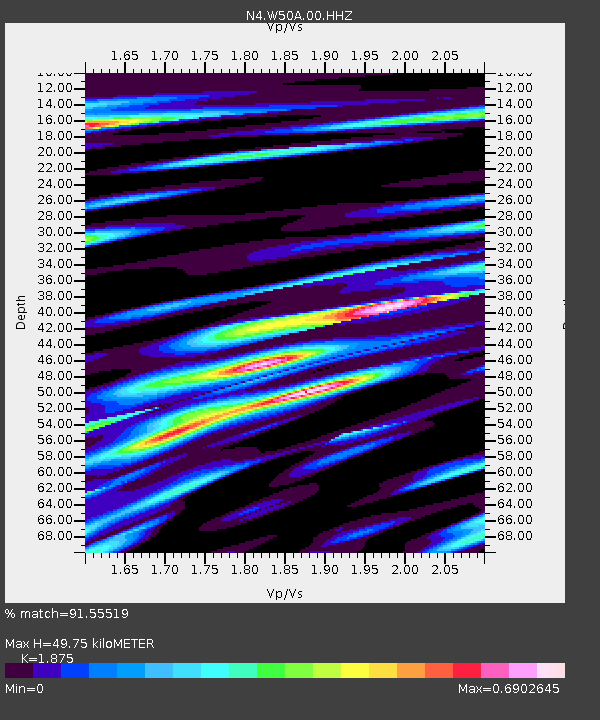
| Estimated Moho Depth: |
49.75 km |
| Estimated Crust Vp/Vs: |
1.88 |
| Assumed Crust Vp: |
6.35 km/s |
| Estimated Crust Vs: |
3.387 km/s |
| Estimated Crust Poisson's Ratio: |
0.30 |
|
| Radial Match: |
91.55519 % |
| Radial Bump: |
400 |
| Transverse Match: |
70.615486 % |
| Transverse Bump: |
400 |
| SOD ConfigId: |
21709731 |
| Insert Time: |
2020-09-13 21:35:03.752 +0000 |
| GWidth: |
2.5 |
| Max Bumps: |
400 |
| Tol: |
0.001 |
|

Signal To Noise
| Channel | StoN | STA | LTA |
| N4:W50A:00:HHZ:20200830T21:30:16.978976Z | 4.2229266 | 4.5765213E-7 | 1.08373214E-7 |
| N4:W50A:00:HH1:20200830T21:30:16.978976Z | 1.2597624 | 1.1589481E-7 | 9.199735E-8 |
| N4:W50A:00:HH2:20200830T21:30:16.978976Z | 1.677411 | 1.8226821E-7 | 1.08660444E-7 |
| Arrivals |
| Ps | 7.1 SECOND |
| PpPs | 22 SECOND |
| PsPs/PpSs | 29 SECOND |


