You are here: Home > Network List > GO - National Seismic Network of Georgia Stations List
> Station TBLG Delisi, Georgia > Earthquake Result Viewer
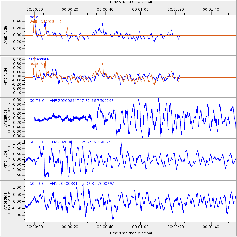
TBLG Delisi, Georgia - Earthquake Result Viewer
*The percent match for this event was below the threshold and hence no stack was calculated.
| Earthquake location: |
Chagos Archipelago Region |
| Earthquake latitude/longitude: |
-4.1/70.3 |
| Earthquake time(UTC): |
2020/08/31 (244) 17:24:04 GMT |
| Earthquake Depth: |
10 km |
| Earthquake Magnitude: |
6.2 mww |
| Earthquake Catalog/Contributor: |
NEIC PDE/us |
|
| Network: |
GO National Seismic Network of Georgia |
| Station: |
TBLG Delisi, Georgia |
| Lat/Lon: |
41.73 N/44.74 E |
| Elevation: |
510 m |
|
| Distance: |
51.2 deg |
| Az: |
335.551 deg |
| Baz: |
146.525 deg |
| Ray Param: |
$rayparam |
*The percent match for this event was below the threshold and hence was not used in the summary stack. |
|
| Radial Match: |
77.27422 % |
| Radial Bump: |
400 |
| Transverse Match: |
70.997734 % |
| Transverse Bump: |
400 |
| SOD ConfigId: |
21709731 |
| Insert Time: |
2020-09-14 17:27:31.441 +0000 |
| GWidth: |
2.5 |
| Max Bumps: |
400 |
| Tol: |
0.001 |
|
Signal To Noise
| Channel | StoN | STA | LTA |
| GO:TBLG: :HHZ:20200831T17:32:36.760029Z | 5.353898 | 5.2864885E-7 | 9.874093E-8 |
| GO:TBLG: :HHN:20200831T17:32:36.760029Z | 2.4318073 | 2.9768242E-7 | 1.2241202E-7 |
| GO:TBLG: :HHE:20200831T17:32:36.760029Z | 2.9425676 | 2.2462815E-7 | 7.6337464E-8 |
| Arrivals |
| Ps | |
| PpPs | |
| PsPs/PpSs | |


