You are here: Home > Network List > GS - US Geological Survey Networks Stations List
> Station KAN09 East Station, Caldwell, KS, USA > Earthquake Result Viewer
KAN09 East Station, Caldwell, KS, USA - Earthquake Result Viewer

| Earthquake location: |
La Rioja Province, Argentina |
| Earthquake latitude/longitude: |
-28.6/-68.7 |
| Earthquake time(UTC): |
2017/08/01 (213) 06:13:53 GMT |
| Earthquake Depth: |
85 km |
| Earthquake Magnitude: |
5.6 Mww |
| Earthquake Catalog/Contributor: |
NEIC PDE/us |
|
| Network: |
GS US Geological Survey Networks |
| Station: |
KAN09 East Station, Caldwell, KS, USA |
| Lat/Lon: |
37.14 N/97.62 W |
| Elevation: |
371 m |
|
| Distance: |
70.8 deg |
| Az: |
335.844 deg |
| Baz: |
153.226 deg |
| Ray Param: |
0.054566212 |
| Estimated Moho Depth: |
35.5 km |
| Estimated Crust Vp/Vs: |
1.79 |
| Assumed Crust Vp: |
6.483 km/s |
| Estimated Crust Vs: |
3.617 km/s |
| Estimated Crust Poisson's Ratio: |
0.27 |
|
| Radial Match: |
89.764206 % |
| Radial Bump: |
400 |
| Transverse Match: |
93.29208 % |
| Transverse Bump: |
400 |
| SOD ConfigId: |
2140511 |
| Insert Time: |
2017-08-14 22:08:40.270 +0000 |
| GWidth: |
2.5 |
| Max Bumps: |
400 |
| Tol: |
0.001 |
|
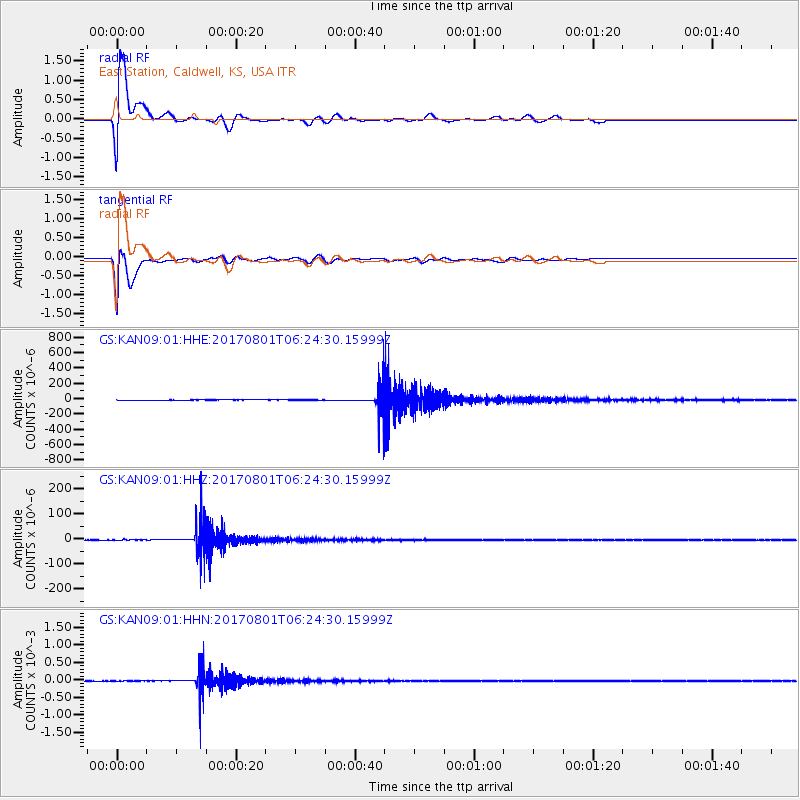
Signal To Noise
| Channel | StoN | STA | LTA |
| GS:KAN09:01:HHZ:20170801T06:24:30.15999Z | 5.462437 | 1.3640499E-6 | 2.4971453E-7 |
| GS:KAN09:01:HHN:20170801T06:24:30.15999Z | 0.89955443 | 5.5243135E-7 | 6.141167E-7 |
| GS:KAN09:01:HHE:20170801T06:24:30.15999Z | 0.6948681 | 6.005594E-7 | 8.642783E-7 |
| Arrivals |
| Ps | 4.5 SECOND |
| PpPs | 15 SECOND |
| PsPs/PpSs | 19 SECOND |


