You are here: Home > Network List > US - United States National Seismic Network Stations List
> Station MNTX Cornudas Mountains, Texas, USA > Earthquake Result Viewer
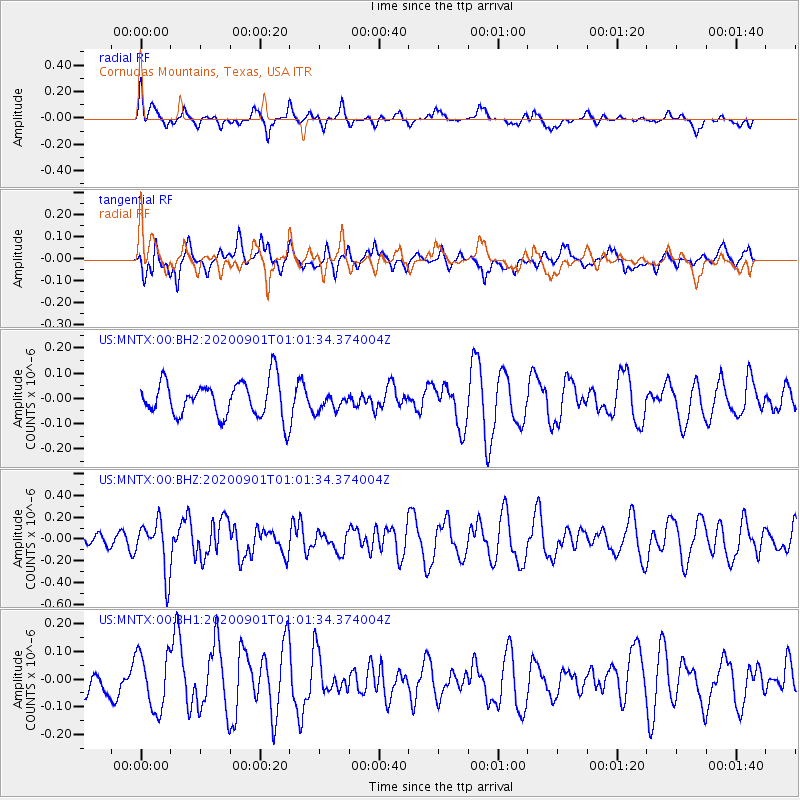
MNTX Cornudas Mountains, Texas, USA - Earthquake Result Viewer
*The percent match for this event was below the threshold and hence no stack was calculated.
| Earthquake location: |
Kamchatka Peninsula, Russia |
| Earthquake latitude/longitude: |
58.7/159.0 |
| Earthquake time(UTC): |
2020/09/01 (245) 00:51:17 GMT |
| Earthquake Depth: |
10 km |
| Earthquake Magnitude: |
5.6 Mww |
| Earthquake Catalog/Contributor: |
NEIC PDE/us |
|
| Network: |
US United States National Seismic Network |
| Station: |
MNTX Cornudas Mountains, Texas, USA |
| Lat/Lon: |
31.70 N/105.38 W |
| Elevation: |
404 m |
|
| Distance: |
66.3 deg |
| Az: |
67.905 deg |
| Baz: |
325.455 deg |
| Ray Param: |
$rayparam |
*The percent match for this event was below the threshold and hence was not used in the summary stack. |
|
| Radial Match: |
47.747555 % |
| Radial Bump: |
384 |
| Transverse Match: |
53.280804 % |
| Transverse Bump: |
400 |
| SOD ConfigId: |
21709731 |
| Insert Time: |
2020-09-15 01:09:33.473 +0000 |
| GWidth: |
2.5 |
| Max Bumps: |
400 |
| Tol: |
0.001 |
|
Signal To Noise
| Channel | StoN | STA | LTA |
| US:MNTX:00:BHZ:20200901T01:01:34.374004Z | 3.4593236 | 2.349272E-7 | 6.791131E-8 |
| US:MNTX:00:BH1:20200901T01:01:34.374004Z | 1.3445283 | 1.0293827E-7 | 7.656088E-8 |
| US:MNTX:00:BH2:20200901T01:01:34.374004Z | 0.5123897 | 3.6529322E-8 | 7.1292064E-8 |
| Arrivals |
| Ps | |
| PpPs | |
| PsPs/PpSs | |


