You are here: Home > Network List > AZ - ANZA Regional Network Stations List
> Station SIO5 Mt. Soledad, La Jolla, CA > Earthquake Result Viewer
SIO5 Mt. Soledad, La Jolla, CA - Earthquake Result Viewer
| Earthquake location: |
Near Coast Of Northern Chile |
| Earthquake latitude/longitude: |
-27.9/-71.5 |
| Earthquake time(UTC): |
2020/09/01 (245) 04:09:24 GMT |
| Earthquake Depth: |
10 km |
| Earthquake Magnitude: |
6.8 Mi |
| Earthquake Catalog/Contributor: |
NEIC PDE/at |
|
| Network: |
AZ ANZA Regional Network |
| Station: |
SIO5 Mt. Soledad, La Jolla, CA |
| Lat/Lon: |
32.84 N/117.25 W |
| Elevation: |
217 m |
|
| Distance: |
74.4 deg |
| Az: |
321.243 deg |
| Baz: |
138.84 deg |
| Ray Param: |
0.052361123 |
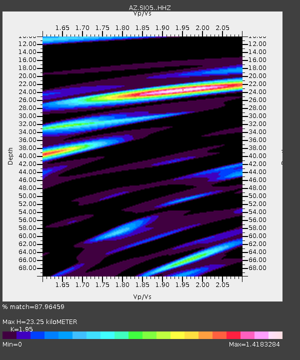
| Estimated Moho Depth: |
23.25 km |
| Estimated Crust Vp/Vs: |
1.95 |
| Assumed Crust Vp: |
6.264 km/s |
| Estimated Crust Vs: |
3.212 km/s |
| Estimated Crust Poisson's Ratio: |
0.32 |
|
| Radial Match: |
87.96459 % |
| Radial Bump: |
400 |
| Transverse Match: |
80.74226 % |
| Transverse Bump: |
400 |
| SOD ConfigId: |
21709731 |
| Insert Time: |
2020-09-15 04:11:03.941 +0000 |
| GWidth: |
2.5 |
| Max Bumps: |
400 |
| Tol: |
0.001 |
|

Signal To Noise
| Channel | StoN | STA | LTA |
| AZ:SIO5: :HHZ:20200901T04:20:30.763Z | 0.7884934 | 3.157809E-7 | 4.004864E-7 |
| AZ:SIO5: :HHN:20200901T04:20:30.763Z | 1.0196826 | 5.7538085E-7 | 5.6427444E-7 |
| AZ:SIO5: :HHE:20200901T04:20:30.763Z | 1.1420494 | 9.038979E-7 | 7.9147003E-7 |
| Arrivals |
| Ps | 3.6 SECOND |
| PpPs | 11 SECOND |
| PsPs/PpSs | 14 SECOND |


