You are here: Home > Network List > GS - US Geological Survey Networks Stations List
> Station PR04 PR04, Ponce > Earthquake Result Viewer
PR04 PR04, Ponce - Earthquake Result Viewer
| Earthquake location: |
Near Coast Of Northern Chile |
| Earthquake latitude/longitude: |
-27.9/-71.5 |
| Earthquake time(UTC): |
2020/09/01 (245) 04:09:24 GMT |
| Earthquake Depth: |
10 km |
| Earthquake Magnitude: |
6.8 Mi |
| Earthquake Catalog/Contributor: |
NEIC PDE/at |
|
| Network: |
GS US Geological Survey Networks |
| Station: |
PR04 PR04, Ponce |
| Lat/Lon: |
17.98 N/66.67 W |
| Elevation: |
57 m |
|
| Distance: |
45.8 deg |
| Az: |
6.412 deg |
| Baz: |
185.961 deg |
| Ray Param: |
0.07102187 |
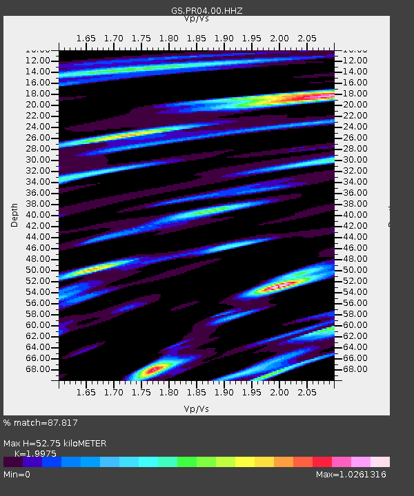
| Estimated Moho Depth: |
52.75 km |
| Estimated Crust Vp/Vs: |
2.00 |
| Assumed Crust Vp: |
4.082 km/s |
| Estimated Crust Vs: |
2.044 km/s |
| Estimated Crust Poisson's Ratio: |
0.33 |
|
| Radial Match: |
87.817 % |
| Radial Bump: |
400 |
| Transverse Match: |
69.42021 % |
| Transverse Bump: |
400 |
| SOD ConfigId: |
21709731 |
| Insert Time: |
2020-09-15 04:16:11.759 +0000 |
| GWidth: |
2.5 |
| Max Bumps: |
400 |
| Tol: |
0.001 |
|

Signal To Noise
| Channel | StoN | STA | LTA |
| GS:PR04:00:HHZ:20200901T04:17:15.253998Z | 11.467585 | 2.8154243E-6 | 2.4551153E-7 |
| GS:PR04:00:HH1:20200901T04:17:15.253998Z | 2.9097295 | 1.1224226E-6 | 3.8574814E-7 |
| GS:PR04:00:HH2:20200901T04:17:15.253998Z | 1.2644585 | 5.465264E-7 | 4.3222164E-7 |
| Arrivals |
| Ps | 13 SECOND |
| PpPs | 38 SECOND |
| PsPs/PpSs | 51 SECOND |


