You are here: Home > Network List > IU - Global Seismograph Network (GSN - IRIS/USGS) Stations List
> Station PMSA Palmer Station, Antarctica > Earthquake Result Viewer
PMSA Palmer Station, Antarctica - Earthquake Result Viewer
| Earthquake location: |
Near Coast Of Northern Chile |
| Earthquake latitude/longitude: |
-27.9/-71.5 |
| Earthquake time(UTC): |
2020/09/01 (245) 04:09:24 GMT |
| Earthquake Depth: |
10 km |
| Earthquake Magnitude: |
6.8 Mi |
| Earthquake Catalog/Contributor: |
NEIC PDE/at |
|
| Network: |
IU Global Seismograph Network (GSN - IRIS/USGS) |
| Station: |
PMSA Palmer Station, Antarctica |
| Lat/Lon: |
64.77 S/64.05 W |
| Elevation: |
40 m |
|
| Distance: |
37.2 deg |
| Az: |
174.725 deg |
| Baz: |
349.054 deg |
| Ray Param: |
0.07628956 |
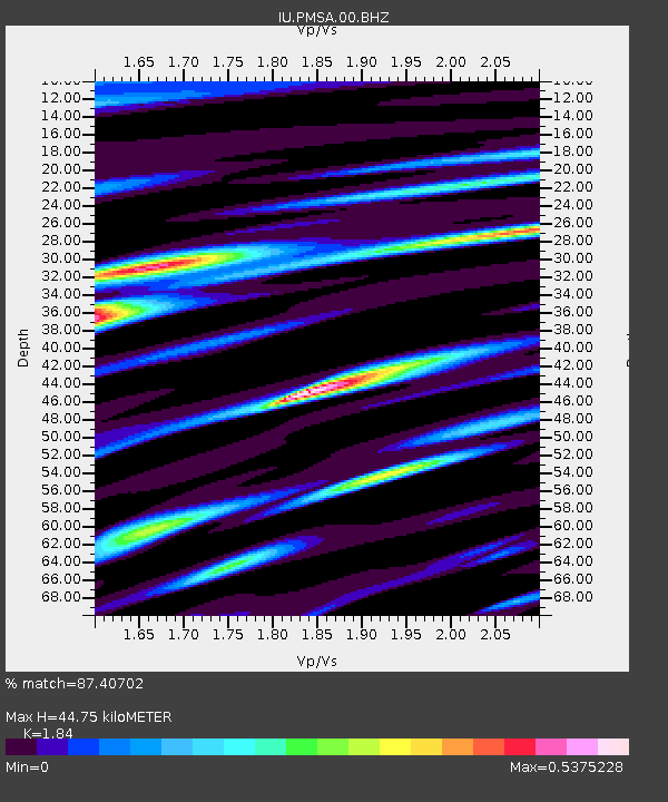
| Estimated Moho Depth: |
44.75 km |
| Estimated Crust Vp/Vs: |
1.84 |
| Assumed Crust Vp: |
6.183 km/s |
| Estimated Crust Vs: |
3.36 km/s |
| Estimated Crust Poisson's Ratio: |
0.29 |
|
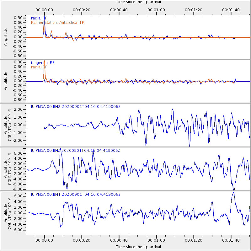
| Radial Match: |
87.40702 % |
| Radial Bump: |
354 |
| Transverse Match: |
79.97744 % |
| Transverse Bump: |
400 |
| SOD ConfigId: |
21709731 |
| Insert Time: |
2020-09-15 04:16:54.778 +0000 |
| GWidth: |
2.5 |
| Max Bumps: |
400 |
| Tol: |
0.001 |
|
Signal To Noise
| Channel | StoN | STA | LTA |
| IU:PMSA:00:BHZ:20200901T04:16:04.419006Z | 6.901529 | 1.5607217E-6 | 2.2614144E-7 |
| IU:PMSA:00:BH1:20200901T04:16:04.419006Z | 2.2769785 | 8.750648E-7 | 3.8430966E-7 |
| IU:PMSA:00:BH2:20200901T04:16:04.419006Z | 1.4990971 | 2.4022142E-7 | 1.6024407E-7 |
| Arrivals |
| Ps | 6.5 SECOND |
| PpPs | 19 SECOND |
| PsPs/PpSs | 26 SECOND |


