You are here: Home > Network List > N4 - Central and EAstern US Network Stations List
> Station E38A The Farm, Brule, WI, USA > Earthquake Result Viewer
E38A The Farm, Brule, WI, USA - Earthquake Result Viewer
| Earthquake location: |
Near Coast Of Northern Chile |
| Earthquake latitude/longitude: |
-27.9/-71.5 |
| Earthquake time(UTC): |
2020/09/01 (245) 04:09:24 GMT |
| Earthquake Depth: |
10 km |
| Earthquake Magnitude: |
6.8 Mi |
| Earthquake Catalog/Contributor: |
NEIC PDE/at |
|
| Network: |
N4 Central and EAstern US Network |
| Station: |
E38A The Farm, Brule, WI, USA |
| Lat/Lon: |
46.61 N/91.55 W |
| Elevation: |
341 m |
|
| Distance: |
76.3 deg |
| Az: |
345.919 deg |
| Baz: |
161.801 deg |
| Ray Param: |
0.05106336 |
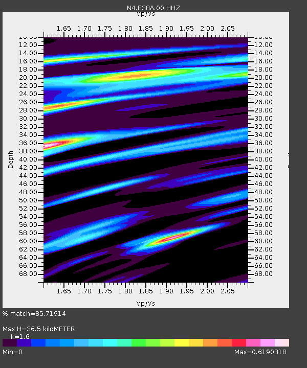
| Estimated Moho Depth: |
36.5 km |
| Estimated Crust Vp/Vs: |
1.60 |
| Assumed Crust Vp: |
6.467 km/s |
| Estimated Crust Vs: |
4.042 km/s |
| Estimated Crust Poisson's Ratio: |
0.18 |
|
| Radial Match: |
85.71914 % |
| Radial Bump: |
400 |
| Transverse Match: |
70.95912 % |
| Transverse Bump: |
400 |
| SOD ConfigId: |
21709731 |
| Insert Time: |
2020-09-15 04:17:57.860 +0000 |
| GWidth: |
2.5 |
| Max Bumps: |
400 |
| Tol: |
0.001 |
|

Signal To Noise
| Channel | StoN | STA | LTA |
| N4:E38A:00:HHZ:20200901T04:20:41.840027Z | 2.578717 | 6.971323E-7 | 2.7034076E-7 |
| N4:E38A:00:HH1:20200901T04:20:41.840027Z | 0.80826825 | 2.4771282E-7 | 3.0647354E-7 |
| N4:E38A:00:HH2:20200901T04:20:41.840027Z | 0.7220328 | 2.3706042E-7 | 3.2832364E-7 |
| Arrivals |
| Ps | 3.5 SECOND |
| PpPs | 14 SECOND |
| PsPs/PpSs | 18 SECOND |


