You are here: Home > Network List > NN - Western Great Basin/Eastern Sierra Nevada Stations List
> Station WDEM Washoe County DEM, Nevada > Earthquake Result Viewer
WDEM Washoe County DEM, Nevada - Earthquake Result Viewer
| Earthquake location: |
Near Coast Of Northern Chile |
| Earthquake latitude/longitude: |
-27.9/-71.5 |
| Earthquake time(UTC): |
2020/09/01 (245) 04:09:24 GMT |
| Earthquake Depth: |
10 km |
| Earthquake Magnitude: |
6.8 Mi |
| Earthquake Catalog/Contributor: |
NEIC PDE/at |
|
| Network: |
NN Western Great Basin/Eastern Sierra Nevada |
| Station: |
WDEM Washoe County DEM, Nevada |
| Lat/Lon: |
39.58 N/119.81 W |
| Elevation: |
1572 m |
|
| Distance: |
80.8 deg |
| Az: |
324.228 deg |
| Baz: |
137.972 deg |
| Ray Param: |
0.0480158 |
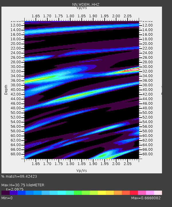
| Estimated Moho Depth: |
30.75 km |
| Estimated Crust Vp/Vs: |
2.10 |
| Assumed Crust Vp: |
6.279 km/s |
| Estimated Crust Vs: |
2.993 km/s |
| Estimated Crust Poisson's Ratio: |
0.35 |
|
| Radial Match: |
89.42423 % |
| Radial Bump: |
400 |
| Transverse Match: |
67.705864 % |
| Transverse Bump: |
400 |
| SOD ConfigId: |
21709731 |
| Insert Time: |
2020-09-15 04:19:47.844 +0000 |
| GWidth: |
2.5 |
| Max Bumps: |
400 |
| Tol: |
0.001 |
|

Signal To Noise
| Channel | StoN | STA | LTA |
| NN:WDEM: :HHZ:20200901T04:21:06.427979Z | 1.6509631 | 1.3259866E-7 | 8.031595E-8 |
| NN:WDEM: :HHN:20200901T04:21:06.427979Z | 0.92201215 | 1.10102214E-7 | 1.1941515E-7 |
| NN:WDEM: :HHE:20200901T04:21:06.427979Z | 0.953739 | 1.4213177E-7 | 1.4902585E-7 |
| Arrivals |
| Ps | 5.5 SECOND |
| PpPs | 15 SECOND |
| PsPs/PpSs | 20 SECOND |


