You are here: Home > Network List > O2 - Oklahoma Consolidated Temporary Seismic Networks Stations List
> Station DRUM Drumwright, Oklahoma, USA > Earthquake Result Viewer
DRUM Drumwright, Oklahoma, USA - Earthquake Result Viewer
| Earthquake location: |
Near Coast Of Northern Chile |
| Earthquake latitude/longitude: |
-27.9/-71.5 |
| Earthquake time(UTC): |
2020/09/01 (245) 04:09:24 GMT |
| Earthquake Depth: |
10 km |
| Earthquake Magnitude: |
6.8 Mi |
| Earthquake Catalog/Contributor: |
NEIC PDE/at |
|
| Network: |
O2 Oklahoma Consolidated Temporary Seismic Networks |
| Station: |
DRUM Drumwright, Oklahoma, USA |
| Lat/Lon: |
35.92 N/96.61 W |
| Elevation: |
296 m |
|
| Distance: |
67.7 deg |
| Az: |
338.154 deg |
| Baz: |
156.063 deg |
| Ray Param: |
0.056764346 |
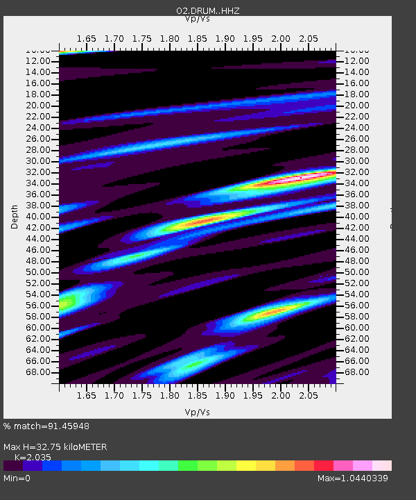
| Estimated Moho Depth: |
32.75 km |
| Estimated Crust Vp/Vs: |
2.04 |
| Assumed Crust Vp: |
6.426 km/s |
| Estimated Crust Vs: |
3.158 km/s |
| Estimated Crust Poisson's Ratio: |
0.34 |
|
| Radial Match: |
91.45948 % |
| Radial Bump: |
295 |
| Transverse Match: |
81.95898 % |
| Transverse Bump: |
400 |
| SOD ConfigId: |
21709731 |
| Insert Time: |
2020-09-15 04:20:17.880 +0000 |
| GWidth: |
2.5 |
| Max Bumps: |
400 |
| Tol: |
0.001 |
|

Signal To Noise
| Channel | StoN | STA | LTA |
| O2:DRUM: :HHZ:20200901T04:19:50.455017Z | 1.9652979 | 2.6501874E-7 | 1.3484915E-7 |
| O2:DRUM: :HHN:20200901T04:19:50.455017Z | 0.96824235 | 1.8096397E-7 | 1.8689946E-7 |
| O2:DRUM: :HHE:20200901T04:19:50.455017Z | 1.9669979 | 4.507517E-7 | 2.291572E-7 |
| Arrivals |
| Ps | 5.5 SECOND |
| PpPs | 15 SECOND |
| PsPs/PpSs | 20 SECOND |


