You are here: Home > Network List > O2 - Oklahoma Consolidated Temporary Seismic Networks Stations List
> Station PW06 Pawnee, Oklahoma, USA > Earthquake Result Viewer
PW06 Pawnee, Oklahoma, USA - Earthquake Result Viewer
| Earthquake location: |
Near Coast Of Northern Chile |
| Earthquake latitude/longitude: |
-27.9/-71.5 |
| Earthquake time(UTC): |
2020/09/01 (245) 04:09:24 GMT |
| Earthquake Depth: |
10 km |
| Earthquake Magnitude: |
6.8 Mi |
| Earthquake Catalog/Contributor: |
NEIC PDE/at |
|
| Network: |
O2 Oklahoma Consolidated Temporary Seismic Networks |
| Station: |
PW06 Pawnee, Oklahoma, USA |
| Lat/Lon: |
36.42 N/96.97 W |
| Elevation: |
303 m |
|
| Distance: |
68.3 deg |
| Az: |
338.082 deg |
| Baz: |
155.821 deg |
| Ray Param: |
0.056378383 |
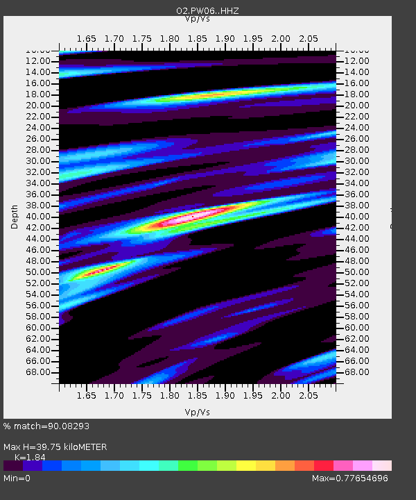
| Estimated Moho Depth: |
39.75 km |
| Estimated Crust Vp/Vs: |
1.84 |
| Assumed Crust Vp: |
6.483 km/s |
| Estimated Crust Vs: |
3.523 km/s |
| Estimated Crust Poisson's Ratio: |
0.29 |
|
| Radial Match: |
90.08293 % |
| Radial Bump: |
400 |
| Transverse Match: |
71.46053 % |
| Transverse Bump: |
400 |
| SOD ConfigId: |
21709731 |
| Insert Time: |
2020-09-15 04:20:29.823 +0000 |
| GWidth: |
2.5 |
| Max Bumps: |
400 |
| Tol: |
0.001 |
|

Signal To Noise
| Channel | StoN | STA | LTA |
| O2:PW06: :HHZ:20200901T04:19:54.075012Z | 0.8017851 | 1.3645025E-7 | 1.7018307E-7 |
| O2:PW06: :HHN:20200901T04:19:54.075012Z | 0.9966111 | 2.4152155E-7 | 2.4234282E-7 |
| O2:PW06: :HHE:20200901T04:19:54.075012Z | 2.0535507 | 5.510396E-7 | 2.6833501E-7 |
| Arrivals |
| Ps | 5.4 SECOND |
| PpPs | 17 SECOND |
| PsPs/PpSs | 22 SECOND |


